Boudouaou geodata
Boudouaou (Boumerdes) is a populated place; located in Algeria in Africa/Algiers (GMT+1) time zone. With population of 45,153 people, there are 111 cities with bigger population in this country. Compared to other cities in Algeria, 88.4% of cities are located further ↓South; 51.2% of cities are located further →East and 96.9% of cities have higher elevation than Boudouaou. Note1


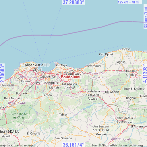
Boudouaou GPS coordinates[2]
36° 43' 38.46" North, 3° 24' 35.82" East
| Map corner | latitude | longitude |
|---|---|---|
| Upper-left | 37.28883°, | 2.70683° |
| Center: | 36.72735°, | 3.40995° |
| Lower-right: | 36.16174°, | 4.11308° |
| Map W x H: | 125.3×125.3 km | = 77.9×77.9mi |
| max Lat: | 36.92917° ⇑11.6% North |
| Boudouaou: | 36.72735° |
| min Lat: | ⇓88.4% South 22.785° |
| min Long | Boudouaou | max Long |
| -8.14743° | 3.40995° | 8.46667° |
| W 48.8%⇐ | ⇒51.2% E |
Elevation
Elevation of Boudouaou is 17 m = 56 ft, and this is 421.5 m = 1383 ft below average elevation for this country.
| Max E: |
1392 m = 4567 ft | 96.9% |
| Avg. | 438.5 m = 1439 ft | |
| Boudouaou | 17 m = 56 ft | |
Min E: |
5 m = 16 ft | 3.1% |
See also: Boudouaou elevation on elevation.city.
Geographical zone
Boudouaou is located in North temperate zone (between Tropic of Cancer and the Arctic Circle). Distance of this Northern Tropic circle is 1477.8 km =918.3 mi to South.| Distance of | km | miles | from Boudouaou |
|---|---|---|---|
| North Pole | 5923.4 | 3680.6 | to North |
| Arctic Circle | 3317.5 | 2061.4 | to North |
| Tropic Cancer | 1477.8 | 918.3 | to South |
| Equator | 4083.7 | 2537.5 | to South |


Nearby cities:
15 places around Boudouaou: (largest is in red/bold)
• Arbatache
10.5 km =6.5 mi,  199°
199°
• Aïn Taya
13.2 km =8.2 mi,  303°
303°
• Bab Ezzouar
20.2 km =12.6 mi,  269°
269°
• Beni Amrane
17.5 km =10.9 mi,  112°
112°
• Bordj el Kiffan
19.5 km =12.1 mi,  276°
276°
• Boumerdas
7.4 km =4.6 mi,  54°
54°
• Chabet el Ameur
27.3 km =17 mi, 111°
• Dar el Beïda
17.7 km =11 mi,  264°
264°
• Khemis el Khechna
11.1 km =6.9 mi,  219°
219°
• Lakhdaria
24.4 km =15.2 mi,  137°
137°
• Meftah
20.5 km =12.7 mi,  234°
234°
• Ouled Moussa
6.2 km =3.9 mi, 218°
• Reghaïa
6.3 km =3.9 mi, 278°
• Rouiba
11.6 km =7.2 mi, 276°
• Thenia
13.1 km =8.1 mi,  90°
90°
Sources, notices
• [Note1] Compared only with cities in Algeria existing in our database
• [Src1] Map data: © OpenStreetMap contributors (CC-BY-SA)
• [Src2] Other city data from geonames.org with taken over terms of usage.
• [Src3] Geographical zone / Annual Mean Temperature by Robert A. Rohde @ Wikipedia
