Rouiba geodata
Rouiba (Algiers) is a populated place; located in Algeria in Africa/Algiers (GMT+1) time zone. With population of 20,742 people, there are 224 cities with bigger population in this country. Compared to other cities in Algeria, 89.9% of cities are located further ↓South; 53.5% of cities are located further →East and 97.3% of cities have higher elevation than Rouiba. Note1


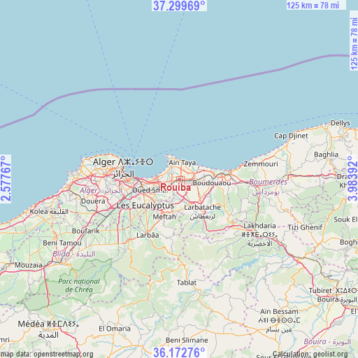
Rouiba GPS coordinates[2]
36° 44' 17.844" North, 3° 16' 50.844" East
| Map corner | latitude | longitude |
|---|---|---|
| Upper-left | 37.29969°, | 2.57767° |
| Center: | 36.73829°, | 3.28079° |
| Lower-right: | 36.17276°, | 3.98392° |
| Map W x H: | 125.3×125.3 km | = 77.9×77.9mi |
| max Lat: | 36.92917° ⇑10.1% North |
| Rouiba: | 36.73829° |
| min Lat: | ⇓89.9% South 22.785° |
| min Long | Rouiba | max Long |
| -8.14743° | 3.28079° | 8.46667° |
| W 46.5%⇐ | ⇒53.5% E |
Elevation
Elevation of Rouiba is 16 m = 52 ft, and this is 422.5 m = 1386 ft below average elevation for this country.
| Max E: |
1392 m = 4567 ft | 97.3% |
| Avg. | 438.5 m = 1439 ft | |
| Rouiba | 16 m = 52 ft | |
Min E: |
5 m = 16 ft | 2.7% |
See also: Algeria elevation on elevation.city.
Geographical zone
Rouiba is located in North temperate zone (between Tropic of Cancer and the Arctic Circle). Distance of this Northern Tropic circle is 1479 km =919 mi to South.| Distance of | km | miles | from Rouiba |
|---|---|---|---|
| North Pole | 5922.1 | 3679.8 | to North |
| Arctic Circle | 3316.3 | 2060.7 | to North |
| Tropic Cancer | 1479 | 919 | to South |
| Equator | 4084.9 | 2538.2 | to South |


Nearby cities:
15 places around Rouiba: (largest is in red/bold)
• Algiers
17.2 km =10.7 mi,  267°
267°
• Arbatache
13.8 km =8.6 mi,  144°
144°
• Aïn Taya
6.1 km =3.8 mi,  5°
5°
• Bab Ezzouar
8.8 km =5.5 mi,  261°
261°
• Baraki
18.3 km =11.4 mi,  244°
244°
• Birkhadem
20.7 km =12.9 mi, 262°
• Bordj el Kiffan
8 km =5 mi,  278°
278°
• Boudouaou
11.6 km =7.2 mi,  96°
96°
• Boumerdas
17.8 km =11.1 mi,  79°
79°
• Dar el Beïda
6.7 km =4.2 mi,  245°
245°
• Khemis el Khechna
10.8 km =6.7 mi,  155°
155°
• Larbaâ
22.4 km =13.9 mi,  210°
210°
• Meftah
14.1 km =8.8 mi,  201°
201°
• Ouled Moussa
9.7 km =6 mi,  128°
128°
• Reghaïa
5.3 km =3.3 mi,  92°
92°
Sources, notices
• [Note1] Compared only with cities in Algeria existing in our database
• [Src1] Map data: © OpenStreetMap contributors (CC-BY-SA)
• [Src2] Other city data from geonames.org with taken over terms of usage.
• [Src3] Geographical zone / Annual Mean Temperature by Robert A. Rohde @ Wikipedia
