Boumerdas geodata
Boumerdas (Boumerdes) is a seat of a first-order administrative division; located in Algeria in Africa/Algiers (GMT+1) time zone. With population of 786,499 people, there is 1 city with bigger population in this country. Compared to other cities in Algeria, 93% of cities are located further ↓South; 50.8% of cities are located further →East and 100% of cities have higher elevation than Boumerdas. Note1


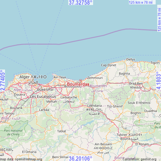
Boumerdas GPS coordinates[2]
36° 45' 59.004" North, 3° 28' 37.812" East
| Map corner | latitude | longitude |
|---|---|---|
| Upper-left | 37.32758°, | 2.77405° |
| Center: | 36.76639°, | 3.47717° |
| Lower-right: | 36.20106°, | 4.1803° |
| Map W x H: | 125.3×125.3 km | = 77.9×77.9mi |
| max Lat: | 36.92917° ⇑7% North |
| Boumerdas: | 36.76639° |
| min Lat: | ⇓93% South 22.785° |
| min Long | Boumerdas | max Long |
| -8.14743° | 3.47717° | 8.46667° |
| W 49.2%⇐ | ⇒50.8% E |
Elevation
Elevation of Boumerdas is 5 m = 16 ft, and this is 433.5 m = 1422 ft below average elevation for this country.
| Max E: |
1392 m = 4567 ft | 100% |
| Avg. | 438.5 m = 1439 ft | |
| Boumerdas | 5 m = 16 ft | |
Min E: |
5 m = 16 ft | 0% |
See also: Boumerdas elevation on elevation.city.
Geographical zone
Boumerdas is located in North temperate zone (between Tropic of Cancer and the Arctic Circle). Distance of this Northern Tropic circle is 1482.1 km =920.9 mi to South.| Distance of | km | miles | from Boumerdas |
|---|---|---|---|
| North Pole | 5919 | 3677.9 | to North |
| Arctic Circle | 3313.1 | 2058.7 | to North |
| Tropic Cancer | 1482.1 | 920.9 | to South |
| Equator | 4088 | 2540.2 | to South |


Nearby cities:
15 places around Boumerdas: (largest is in red/bold)
• Arbatache
17.1 km =10.6 mi,  213°
213°
• Aïn Taya
17.2 km =10.7 mi,  280°
280°
• Bab Ezzouar
26.6 km =16.5 mi,  260°
260°
• Beni Amrane
15 km =9.3 mi,  137°
137°
• Bordj el Kiffan
25.4 km =15.8 mi,  265°
265°
• Boudouaou
7.4 km =4.6 mi,  234°
234°
• Chabet el Ameur
24.1 km =15 mi,  126°
126°
• Dar el Beïda
24.3 km =15.1 mi, 255°
• Khemis el Khechna
18.4 km =11.4 mi, 225°
• Lakhdaria
24.7 km =15.3 mi,  155°
155°
• Meftah
27.9 km =17.3 mi, 234°
• Ouled Moussa
13.5 km =8.4 mi, 227°
• Reghaïa
12.7 km =7.9 mi,  254°
254°
• Rouiba
17.8 km =11.1 mi, 259°
• Thenia
8.4 km =5.2 mi,  122°
122°
Sources, notices
• [Note1] Compared only with cities in Algeria existing in our database
• [Src1] Map data: © OpenStreetMap contributors (CC-BY-SA)
• [Src2] Other city data from geonames.org with taken over terms of usage.
• [Src3] Geographical zone / Annual Mean Temperature by Robert A. Rohde @ Wikipedia
