Oued el Abtal geodata
Oued el Abtal (Mascara) is a populated place; located in Algeria in Africa/Algiers (GMT+1) time zone. With population of 22,819 people, there are 212 cities with bigger population in this country. Compared to other cities in Algeria, 67.4% of cities are located further ↑North; 83.3% of cities are located further →East and 53.5% of cities have higher elevation than Oued el Abtal. Note1


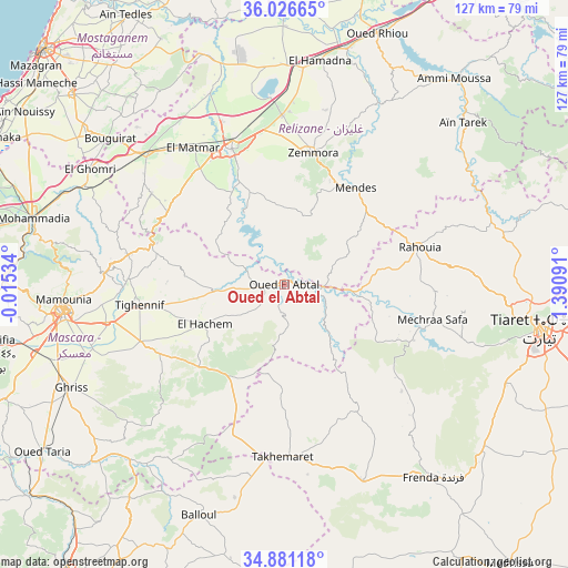
Oued el Abtal GPS coordinates[2]
35° 27' 21.42" North, 0° 41' 16.008" East
| Map corner | latitude | longitude |
|---|---|---|
| Upper-left | 36.02665°, | -0.01534° |
| Center: | 35.45595°, | 0.68778° |
| Lower-right: | 34.88118°, | 1.39091° |
| Map W x H: | 127.4×127.4 km | = 79.2×79.2mi |
| max Lat: | 36.92917° ⇑67.4% North |
| Oued el Abtal: | 35.45595° |
| min Lat: | ⇓32.6% South 22.785° |
| min Long | Oued el Abtal | max Long |
| -8.14743° | 0.68778° | 8.46667° |
| W 16.7%⇐ | ⇒83.3% E |
Elevation
Elevation of Oued el Abtal is 259 m = 850 ft, and this is 179.5 m = 589 ft below average elevation for this country.
| Max E: |
1392 m = 4567 ft | 53.5% |
| Avg. | 438.5 m = 1439 ft | |
| Oued el Abtal | 259 m = 850 ft | |
Min E: |
5 m = 16 ft | 46.5% |
See also: Algeria elevation on elevation.city.
Geographical zone
Oued el Abtal is located in North temperate zone (between Tropic of Cancer and the Arctic Circle). Distance of this Northern Tropic circle is 1336.4 km =830.4 mi to South.| Distance of | km | miles | from Oued el Abtal |
|---|---|---|---|
| North Pole | 6064.7 | 3768.4 | to North |
| Arctic Circle | 3458.8 | 2149.2 | to North |
| Tropic Cancer | 1336.4 | 830.4 | to South |
| Equator | 3942.3 | 2449.6 | to South |


Nearby cities:
15 places around Oued el Abtal: (largest is in red/bold)
• Ammi Moussa
59.7 km =37.1 mi,  39°
39°
• Bou Hanifia el Hamamat
68.7 km =42.7 mi,  256°
256°
• Boukadir
78.5 km =48.8 mi,  30°
30°
• Djebilet Rosfa
67.2 km =41.8 mi,  168°
168°
• Djidiouia
54.2 km =33.7 mi,  13°
13°
• Frenda
54.4 km =33.8 mi,  142°
142°
• Mascara
50 km =31.1 mi, 262°
• Mazouna
76.5 km =47.5 mi, 14°
• Mostaganem
75.6 km =47 mi,  314°
314°
• Oued Rhiou
59.9 km =37.2 mi,  20°
20°
• Relizane
33.5 km =20.8 mi,  339°
339°
• Rouachdia
28.3 km =17.6 mi, 7°
• Smala
29.6 km =18.4 mi, 11°
• Tiaret
57.8 km =35.9 mi,  99°
99°
• Zemoura
30.3 km =18.8 mi, 11°
Sources, notices
• [Note1] Compared only with cities in Algeria existing in our database
• [Src1] Map data: © OpenStreetMap contributors (CC-BY-SA)
• [Src2] Other city data from geonames.org with taken over terms of usage.
• [Src3] Geographical zone / Annual Mean Temperature by Robert A. Rohde @ Wikipedia
