Besbes geodata
Besbes (El Tarf) is a populated place; located in Algeria in Africa/Algiers (GMT+1) time zone. With population of 66,287 people, there are 68 cities with bigger population in this country. Compared to other cities in Algeria, 85.3% of cities are located further ↓South; 96.5% of cities are located further ←West and 96.1% of cities have higher elevation than Besbes. Note1


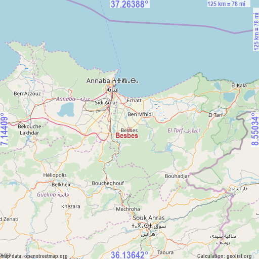
Besbes GPS coordinates[2]
36° 42' 7.992" North, 7° 50' 49.992" East
| Map corner | latitude | longitude |
|---|---|---|
| Upper-left | 37.26388°, | 7.14409° |
| Center: | 36.70222°, | 7.84722° |
| Lower-right: | 36.13642°, | 8.55034° |
| Map W x H: | 125.4×125.4 km | = 77.9×77.9mi |
| max Lat: | 36.92917° ⇑14.7% North |
| Besbes: | 36.70222° |
| min Lat: | ⇓85.3% South 22.785° |
| min Long | Besbes | max Long |
| -8.14743° | 7.84722° | 8.46667° |
| W 96.5%⇐ | ⇒3.5% E |
Elevation
Elevation of Besbes is 20 m = 66 ft, and this is 418.5 m = 1373 ft below average elevation for this country.
| Max E: |
1392 m = 4567 ft | 96.1% |
| Avg. | 438.5 m = 1439 ft | |
| Besbes | 20 m = 66 ft | |
Min E: |
5 m = 16 ft | 3.9% |
See also: Besbes elevation on elevation.city.
Geographical zone
Besbes is located in North temperate zone (between Tropic of Cancer and the Arctic Circle). Distance of this Northern Tropic circle is 1475 km =916.5 mi to South.| Distance of | km | miles | from Besbes |
|---|---|---|---|
| North Pole | 5926.2 | 3682.4 | to North |
| Arctic Circle | 3320.3 | 2063.1 | to North |
| Tropic Cancer | 1475 | 916.5 | to South |
| Equator | 4080.9 | 2535.8 | to South |


Nearby cities:
15 places around Besbes: (largest is in red/bold)
• Annaba
23.1 km =14.4 mi,  341°
341°
• Azzaba
66.3 km =41.2 mi,  273°
273°
• Ben Mehidi
9.2 km =5.7 mi,  35°
35°
• Berrahal
38.1 km =23.7 mi,  292°
292°
• Boumahra Ahmed
40.3 km =25 mi,  227°
227°
• Drean
8.8 km =5.5 mi,  257°
257°
• El Aouinet
92.9 km =57.7 mi,  177°
177°
• El Hadjar
15 km =9.3 mi,  318°
318°
• El Kala
57.3 km =35.6 mi,  67°
67°
• El Tarf
42.2 km =26.2 mi,  80°
80°
• Guelma
46.1 km =28.6 mi, 234°
• Héliopolis
42.3 km =26.3 mi,  238°
238°
• Sedrata
69.7 km =43.3 mi,  203°
203°
• Skikda
85.7 km =53.3 mi,  283°
283°
• Souk Ahras
47.2 km =29.3 mi,  168°
168°
Sources, notices
• [Note1] Compared only with cities in Algeria existing in our database
• [Src1] Map data: © OpenStreetMap contributors (CC-BY-SA)
• [Src2] Other city data from geonames.org with taken over terms of usage.
• [Src3] Geographical zone / Annual Mean Temperature by Robert A. Rohde @ Wikipedia
