Annaba geodata
Annaba is a seat of a first-order administrative division; located in Algeria in Africa/Algiers (GMT+1) time zone. With population of 206,570 people, there are 9 cities with bigger population in this country. Compared to other cities in Algeria, 99.2% of cities are located further ↓South; 96.1% of cities are located further ←West and 100% of cities have higher elevation than Annaba. Note1


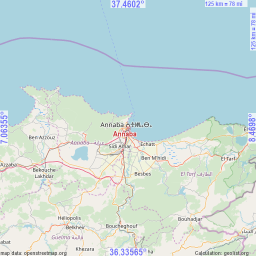
Annaba GPS coordinates[2]
36° 54' 0" North, 7° 46' 0.012" East
| Map corner | latitude | longitude |
|---|---|---|
| Upper-left | 37.4602°, | 7.06355° |
| Center: | 36.9°, | 7.76667° |
| Lower-right: | 36.33565°, | 8.4698° |
| Map W x H: | 125×125 km | = 77.7×77.7mi |
| max Lat: | 36.92917° ⇑0.8% North |
| Annaba: | 36.9° |
| min Lat: | ⇓99.2% South 22.785° |
| min Long | Annaba | max Long |
| -8.14743° | 7.76667° | 8.46667° |
| W 96.1%⇐ | ⇒3.9% E |
Elevation
Elevation of Annaba is 5 m = 16 ft, and this is 433.5 m = 1422 ft below average elevation for this country.
| Max E: |
1392 m = 4567 ft | 100% |
| Avg. | 438.5 m = 1439 ft | |
| Annaba | 5 m = 16 ft | |
Min E: |
5 m = 16 ft | 0% |
See also: Annaba elevation on elevation.city.
Geographical zone
Annaba is located in North temperate zone (between Tropic of Cancer and the Arctic Circle). Distance of this Northern Tropic circle is 1497 km =930.2 mi to South.| Distance of | km | miles | from Annaba |
|---|---|---|---|
| North Pole | 5904.2 | 3668.7 | to North |
| Arctic Circle | 3298.3 | 2049.5 | to North |
| Tropic Cancer | 1497 | 930.2 | to South |
| Equator | 4102.9 | 2549.4 | to South |


Nearby cities:
15 places around Annaba: (largest is in red/bold)
• Azzaba
61.5 km =38.2 mi,  253°
253°
• Ben Mehidi
19.1 km =11.9 mi,  139°
139°
• Berrahal
28.8 km =17.9 mi,  255°
255°
• Besbes
23.1 km =14.4 mi,  161°
161°
• Boumahra Ahmed
54 km =33.6 mi,  204°
204°
• Drean
24 km =14.9 mi,  183°
183°
• El Hadjar
11 km =6.8 mi,  193°
193°
• El Kala
60.2 km =37.4 mi,  90°
90°
• El Tarf
50.9 km =31.6 mi,  106°
106°
• Guelma
57.4 km =35.7 mi,  211°
211°
• Héliopolis
52.7 km =32.7 mi, 213°
• Sedrata
88.3 km =54.9 mi, 193°
• Skikda
76.3 km =47.4 mi,  268°
268°
• Souk Ahras
70.2 km =43.6 mi,  166°
166°
• Tamalous
100.4 km =62.4 mi, 266°
Sources, notices
• [Note1] Compared only with cities in Algeria existing in our database
• [Src1] Map data: © OpenStreetMap contributors (CC-BY-SA)
• [Src2] Other city data from geonames.org with taken over terms of usage.
• [Src3] Geographical zone / Annual Mean Temperature by Robert A. Rohde @ Wikipedia
