Sedrata geodata
Sedrata (Souk Ahras) is a populated place; located in Algeria in Africa/Algiers (GMT+1) time zone. With population of 53,318 people, there are 90 cities with bigger population in this country. Compared to other cities in Algeria, 52.3% of cities are located further ↓South; 94.2% of cities are located further ←West and 75.2% of cities have lower elevation than Sedrata. Note1


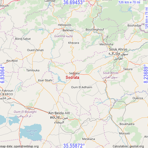
Sedrata GPS coordinates[2]
36° 7' 43.248" North, 7° 32' 1.536" East
| Map corner | latitude | longitude |
|---|---|---|
| Upper-left | 36.69453°, | 6.83064° |
| Center: | 36.12868°, | 7.53376° |
| Lower-right: | 35.55872°, | 8.23689° |
| Map W x H: | 126.3×126.3 km | = 78.5×78.5mi |
| max Lat: | 36.92917° ⇑47.7% North |
| Sedrata: | 36.12868° |
| min Lat: | ⇓52.3% South 22.785° |
| min Long | Sedrata | max Long |
| -8.14743° | 7.53376° | 8.46667° |
| W 94.2%⇐ | ⇒5.8% E |
Elevation
Elevation of Sedrata is 794 m = 2605 ft, and this is 355.5 m = 1166 ft above average elevation for this country.
| Max E: |
1392 m = 4567 ft | 24.8% |
| Sedrata | 794 m 2605 ft | |
| Avg. | 438.5 m = 1439 ft | |
Min E: |
5 m = 16 ft | 75.2% |
See also: Sedrata elevation on elevation.city.
Geographical zone
Sedrata is located in North temperate zone (between Tropic of Cancer and the Arctic Circle). Distance of this Northern Tropic circle is 1411.2 km =876.9 mi to South.| Distance of | km | miles | from Sedrata |
|---|---|---|---|
| North Pole | 5989.9 | 3722 | to North |
| Arctic Circle | 3384 | 2102.7 | to North |
| Tropic Cancer | 1411.2 | 876.9 | to South |
| Equator | 4017.1 | 2496.1 | to South |


Nearby cities:
15 places around Sedrata: (largest is in red/bold)
• Azzaba
78 km =48.5 mi,  330°
330°
• Aïn Beïda
39.1 km =24.3 mi,  198°
198°
• Aïn Fakroun
61.9 km =38.5 mi,  253°
253°
• Besbes
69.7 km =43.3 mi,  23°
23°
• Boumahra Ahmed
36.7 km =22.8 mi,  357°
357°
• Drean
64.8 km =40.3 mi, 17°
• El Aouinet
43.1 km =26.8 mi,  132°
132°
• El Hadjar
77.2 km =48 mi,  13°
13°
• El Khroub
76.9 km =47.8 mi,  281°
281°
• Guelma
38.3 km =23.8 mi,  345°
345°
• Héliopolis
42.5 km =26.4 mi, 348°
• Meskiana
56.7 km =35.2 mi,  167°
167°
• Oum el Bouaghi
47.1 km =29.3 mi,  233°
233°
• Souk Ahras
41.3 km =25.7 mi,  64°
64°
• ’Aïn Abid
54.2 km =33.7 mi, 282°
Sources, notices
• [Note1] Compared only with cities in Algeria existing in our database
• [Src1] Map data: © OpenStreetMap contributors (CC-BY-SA)
• [Src2] Other city data from geonames.org with taken over terms of usage.
• [Src3] Geographical zone / Annual Mean Temperature by Robert A. Rohde @ Wikipedia
