Aïn Beïda geodata
Aïn Beïda (Oum el Bouaghi) is a populated place; located in Algeria in Africa/Algiers (GMT+1) time zone. With population of 105,765 people, there are 38 cities with bigger population in this country. Compared to other cities in Algeria, 57.8% of cities are located further ↑North; 92.2% of cities are located further ←West and 89.1% of cities have lower elevation than Aïn Beïda. Note1


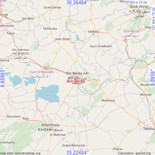
Aïn Beïda GPS coordinates[2]
35° 47' 47.004" North, 7° 23' 34.008" East
| Map corner | latitude | longitude |
|---|---|---|
| Upper-left | 36.36464°, | 6.68965° |
| Center: | 35.79639°, | 7.39278° |
| Lower-right: | 35.22404°, | 8.0959° |
| Map W x H: | 126.8×126.8 km | = 78.8×78.8mi |
| max Lat: | 36.92917° ⇑57.8% North |
| Aïn Beïda: | 35.79639° |
| min Lat: | ⇓42.2% South 22.785° |
| min Long | Aïn Beïda | max Long |
| -8.14743° | 7.39278° | 8.46667° |
| W 92.2%⇐ | ⇒7.8% E |
Elevation
Elevation of Aïn Beïda is 1008 m = 3307 ft, and this is 569.5 m = 1868 ft above average elevation for this country.
| Max E: |
1392 m = 4567 ft | 10.9% |
| Aïn Beïda | 1008 m 3307 ft | |
| Avg. | 438.5 m = 1439 ft | |
Min E: |
5 m = 16 ft | 89.1% |
See also: Aïn Beïda elevation on elevation.city.
Geographical zone
Aïn Beïda is located in North temperate zone (between Tropic of Cancer and the Arctic Circle). Distance of this Northern Tropic circle is 1374.3 km =854 mi to South.| Distance of | km | miles | from Aïn Beïda |
|---|---|---|---|
| North Pole | 6026.9 | 3744.9 | to North |
| Arctic Circle | 3421 | 2125.7 | to North |
| Tropic Cancer | 1374.3 | 854 | to South |
| Equator | 3980.2 | 2473.2 | to South |


Nearby cities:
15 places around Aïn Beïda: (largest is in red/bold)
• Aïn Fakroun
50.6 km =31.4 mi,  292°
292°
• Aïn Kercha
64.5 km =40.1 mi,  282°
282°
• Boumahra Ahmed
74.4 km =46.2 mi,  8°
8°
• Cheria
66.6 km =41.4 mi,  150°
150°
• El Aouinet
45.2 km =28.1 mi,  80°
80°
• Guelma
74.1 km =46 mi,  2°
2°
• Hammamet
63.6 km =39.5 mi,  127°
127°
• Héliopolis
78.8 km =49 mi, 3°
• Khenchela
46 km =28.6 mi,  209°
209°
• Meskiana
30.8 km =19.1 mi, 126°
• Oum el Bouaghi
26.7 km =16.6 mi, 289°
• Sedrata
39.1 km =24.3 mi,  18°
18°
• Souk Ahras
74.1 km =46 mi,  42°
42°
• Tébessa
79.2 km =49.2 mi,  123°
123°
• ’Aïn Abid
63.1 km =39.2 mi,  320°
320°
Sources, notices
• [Note1] Compared only with cities in Algeria existing in our database
• [Src1] Map data: © OpenStreetMap contributors (CC-BY-SA)
• [Src2] Other city data from geonames.org with taken over terms of usage.
• [Src3] Geographical zone / Annual Mean Temperature by Robert A. Rohde @ Wikipedia
