Oum el Bouaghi geodata
Oum el Bouaghi is a seat of a first-order administrative division; located in Algeria in Africa/Algiers (GMT+1) time zone. With population of 100,821 people, there are 40 cities with bigger population in this country. Compared to other cities in Algeria, 55.4% of cities are located further ↑North; 91.5% of cities are located further ←West and 84.9% of cities have lower elevation than Oum el Bouaghi. Note1


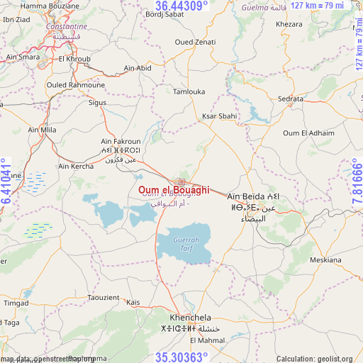
Oum el Bouaghi GPS coordinates[2]
35° 52' 31.476" North, 7° 6' 48.708" East
| Map corner | latitude | longitude |
|---|---|---|
| Upper-left | 36.44309°, | 6.41041° |
| Center: | 35.87541°, | 7.11353° |
| Lower-right: | 35.30363°, | 7.81666° |
| Map W x H: | 126.7×126.7 km | = 78.7×78.7mi |
| max Lat: | 36.92917° ⇑55.4% North |
| Oum el Bouaghi: | 35.87541° |
| min Lat: | ⇓44.6% South 22.785° |
| min Long | Oum el Bouaghi | max Long |
| -8.14743° | 7.11353° | 8.46667° |
| W 91.5%⇐ | ⇒8.5% E |
Elevation
Elevation of Oum el Bouaghi is 925 m = 3035 ft, and this is 486.5 m = 1596 ft above average elevation for this country.
| Max E: |
1392 m = 4567 ft | 15.1% |
| Oum el Bouaghi | 925 m 3035 ft | |
| Avg. | 438.5 m = 1439 ft | |
Min E: |
5 m = 16 ft | 84.9% |
See also: Oum el Bouaghi elevation on elevation.city.
Geographical zone
Oum el Bouaghi is located in North temperate zone (between Tropic of Cancer and the Arctic Circle). Distance of this Northern Tropic circle is 1383.1 km =859.4 mi to South.| Distance of | km | miles | from Oum el Bouaghi |
|---|---|---|---|
| North Pole | 6018.1 | 3739.5 | to North |
| Arctic Circle | 3412.2 | 2120.2 | to North |
| Tropic Cancer | 1383.1 | 859.4 | to South |
| Equator | 3989 | 2478.6 | to South |


Nearby cities:
15 places around Oum el Bouaghi: (largest is in red/bold)
• Aïn Beïda
26.7 km =16.6 mi,  109°
109°
• Aïn Fakroun
24.1 km =15 mi,  296°
296°
• Aïn Kercha
38.1 km =23.7 mi,  278°
278°
• Aïn Smara
70.2 km =43.6 mi,  308°
308°
• Boumahra Ahmed
74.1 km =46 mi,  29°
29°
• Constantine
70.5 km =43.8 mi,  320°
320°
• El Aouinet
69.7 km =43.3 mi,  90°
90°
• El Khroub
57.3 km =35.6 mi, 318°
• Guelma
71 km =44.1 mi,  23°
23°
• Hamma Bouziane
75.6 km =47 mi, 322°
• Khenchela
49 km =30.4 mi,  176°
176°
• Meskiana
56.8 km =35.3 mi,  118°
118°
• Sedrata
47.1 km =29.3 mi,  53°
53°
• Telerghma
73.4 km =45.6 mi,  291°
291°
• ’Aïn Abid
42.5 km =26.4 mi,  338°
338°
Sources, notices
• [Note1] Compared only with cities in Algeria existing in our database
• [Src1] Map data: © OpenStreetMap contributors (CC-BY-SA)
• [Src2] Other city data from geonames.org with taken over terms of usage.
• [Src3] Geographical zone / Annual Mean Temperature by Robert A. Rohde @ Wikipedia
