Aïn Fakroun geodata
Aïn Fakroun (Oum el Bouaghi) is a populated place; located in Algeria in Africa/Algiers (GMT+1) time zone. With population of 68,433 people, there are 63 cities with bigger population in this country. Compared to other cities in Algeria, 51.6% of cities are located further ↑North; 89.1% of cities are located further ←West and 87.2% of cities have lower elevation than Aïn Fakroun. Note1


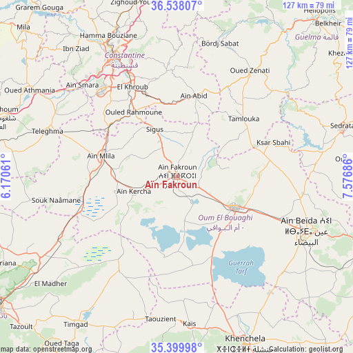
Aïn Fakroun GPS coordinates[2]
35° 58' 15.888" North, 6° 52' 25.464" East
| Map corner | latitude | longitude |
|---|---|---|
| Upper-left | 36.53807°, | 6.17061° |
| Center: | 35.97108°, | 6.87374° |
| Lower-right: | 35.39998°, | 7.57686° |
| Map W x H: | 126.5×126.5 km | = 78.6×78.6mi |
| max Lat: | 36.92917° ⇑51.6% North |
| Aïn Fakroun: | 35.97108° |
| min Lat: | ⇓48.4% South 22.785° |
| min Long | Aïn Fakroun | max Long |
| -8.14743° | 6.87374° | 8.46667° |
| W 89.1%⇐ | ⇒10.9% E |
Elevation
Elevation of Aïn Fakroun is 953 m = 3127 ft, and this is 514.5 m = 1688 ft above average elevation for this country.
| Max E: |
1392 m = 4567 ft | 12.8% |
| Aïn Fakroun | 953 m 3127 ft | |
| Avg. | 438.5 m = 1439 ft | |
Min E: |
5 m = 16 ft | 87.2% |
See also: Aïn Fakroun elevation on elevation.city.
Geographical zone
Aïn Fakroun is located in North temperate zone (between Tropic of Cancer and the Arctic Circle). Distance of this Northern Tropic circle is 1393.7 km =866 mi to South.| Distance of | km | miles | from Aïn Fakroun |
|---|---|---|---|
| North Pole | 6007.5 | 3732.9 | to North |
| Arctic Circle | 3401.6 | 2113.7 | to North |
| Tropic Cancer | 1393.7 | 866 | to South |
| Equator | 3999.6 | 2485.2 | to South |


Nearby cities:
15 places around Aïn Fakroun: (largest is in red/bold)
• Aïn Beïda
50.6 km =31.4 mi,  112°
112°
• Aïn Kercha
16.9 km =10.5 mi,  252°
252°
• Aïn Smara
46.9 km =29.1 mi,  314°
314°
• Chelghoum el Aïd
67 km =41.6 mi,  288°
288°
• Constantine
49.6 km =30.8 mi,  332°
332°
• Didouche Mourad
57.6 km =35.8 mi,  338°
338°
• El Khroub
36.3 km =22.6 mi, 333°
• Guelma
73.7 km =45.8 mi,  42°
42°
• Hamma Bouziane
55 km =34.2 mi, 333°
• Khenchela
64.3 km =40 mi,  157°
157°
• Mila
76.3 km =47.4 mi, 314°
• Oum el Bouaghi
24.1 km =15 mi,  116°
116°
• Sedrata
61.9 km =38.5 mi,  73°
73°
• Telerghma
49.4 km =30.7 mi, 289°
• ’Aïn Abid
29.7 km =18.5 mi,  12°
12°
Sources, notices
• [Note1] Compared only with cities in Algeria existing in our database
• [Src1] Map data: © OpenStreetMap contributors (CC-BY-SA)
• [Src2] Other city data from geonames.org with taken over terms of usage.
• [Src3] Geographical zone / Annual Mean Temperature by Robert A. Rohde @ Wikipedia
