Telerghma geodata
Telerghma (Mila) is a populated place; located in Algeria in Africa/Algiers (GMT+1) time zone. With population of 51,708 people, there are 96 cities with bigger population in this country. Compared to other cities in Algeria, 51.6% of cities are located further ↓South; 84.5% of cities are located further ←West and 73.3% of cities have lower elevation than Telerghma. Note1


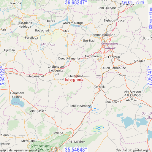
Telerghma GPS coordinates[2]
36° 6' 59.508" North, 6° 21' 15.624" East
| Map corner | latitude | longitude |
|---|---|---|
| Upper-left | 36.68247°, | 5.65122° |
| Center: | 36.11653°, | 6.35434° |
| Lower-right: | 35.54648°, | 7.05747° |
| Map W x H: | 126.3×126.3 km | = 78.5×78.5mi |
| max Lat: | 36.92917° ⇑48.4% North |
| Telerghma: | 36.11653° |
| min Lat: | ⇓51.6% South 22.785° |
| min Long | Telerghma | max Long |
| -8.14743° | 6.35434° | 8.46667° |
| W 84.5%⇐ | ⇒15.5% E |
Elevation
Elevation of Telerghma is 748 m = 2454 ft, and this is 309.5 m = 1015 ft above average elevation for this country.
| Max E: |
1392 m = 4567 ft | 26.7% |
| Telerghma | 748 m 2454 ft | |
| Avg. | 438.5 m = 1439 ft | |
Min E: |
5 m = 16 ft | 73.3% |
See also: Telerghma elevation on elevation.city.
Geographical zone
Telerghma is located in North temperate zone (between Tropic of Cancer and the Arctic Circle). Distance of this Northern Tropic circle is 1409.9 km =876.1 mi to South.| Distance of | km | miles | from Telerghma |
|---|---|---|---|
| North Pole | 5991.3 | 3722.8 | to North |
| Arctic Circle | 3385.4 | 2103.6 | to North |
| Tropic Cancer | 1409.9 | 876.1 | to South |
| Equator | 4015.8 | 2495.3 | to South |


Nearby cities:
15 places around Telerghma: (largest is in red/bold)
• Aïn Fakroun
49.4 km =30.7 mi,  109°
109°
• Aïn Kercha
37.3 km =23.2 mi,  124°
124°
• Aïn Smara
21.3 km =13.2 mi,  38°
38°
• Batna
64.4 km =40 mi,  194°
194°
• Chelghoum el Aïd
17.6 km =10.9 mi,  286°
286°
• Constantine
36.2 km =22.5 mi, 40°
• Didouche Mourad
45.1 km =28 mi,  34°
34°
• El Eulma
59.8 km =37.2 mi,  273°
273°
• El Khroub
34.5 km =21.4 mi,  61°
61°
• Hamma Bouziane
39.4 km =24.5 mi, 33°
• Merouana
67.1 km =41.7 mi,  216°
216°
• Mila
38 km =23.6 mi,  347°
347°
• Rouached
47.1 km =29.3 mi,  323°
323°
• Sidi Mérouane
45.7 km =28.4 mi, 349°
• ’Aïn Abid
54.4 km =33.8 mi,  76°
76°
Sources, notices
• [Note1] Compared only with cities in Algeria existing in our database
• [Src1] Map data: © OpenStreetMap contributors (CC-BY-SA)
• [Src2] Other city data from geonames.org with taken over terms of usage.
• [Src3] Geographical zone / Annual Mean Temperature by Robert A. Rohde @ Wikipedia
