Santa Ana geodata
Santa Ana (Manabí) is a populated place; located in Ecuador in America/Guayaquil (GMT-5) time zone. With population of 12,833 people, there are 71 cities with bigger population in this country. Compared to other cities in Ecuador, 58.7% of cities are located further ↓South; 86.8% of cities are located further →East and 58.7% of cities have higher elevation than Santa Ana. Note1
Administrative division(s):
- Level 1: Manabí
- Level 2: Cantón Santa Ana
- Level 3: Santa Ana De Vuelta Larga


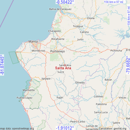
Santa Ana GPS coordinates[2]
1° 12' 26.136" South, 80° 22' 16.752" West
| Map corner | latitude | longitude |
|---|---|---|
| Upper-left | -0.50422°, | -81.07445° |
| Center: | -1.20726°, | -80.37132° |
| Lower-right: | -1.91012°, | -79.6682° |
| Map W x H: | 156.3×156.3 km | = 97.1×97.1mi |
| max Lat: | 1.35251° ⇑41.3% North |
| Santa Ana: | -1.20726° |
| min Lat: | ⇓58.7% South -4.38181° |
| min Long | Santa Ana | max Long |
| -90.96654° | -80.37132° | -76.89528° |
| W 13.2%⇐ | ⇒86.8% E |
Elevation
Elevation of Santa Ana is 61 m = 200 ft, and this is 884.1 m = 2901 ft below average elevation for this country.
| Max E: |
3131 m = 10272 ft | 58.7% |
| Avg. | 945.1 m = 3101 ft | |
| Santa Ana | 61 m = 200 ft | |
Min E: |
1 m = 3 ft | 41.3% |
See also: Ecuador elevation on elevation.city.
Geographical zone
Santa Ana is located in South Torrid zone (between Equator and Tropic of Capricorn). Distance of Equator is 134.2 km =83.4 mi to North.| Distance of | km | miles | from Santa Ana |
|---|---|---|---|
| Equator | 134.2 | 83.4 | to North |
| Tropic Capricorn | 2471.7 | 1535.8 | to South |
| Antarctic Circle | 7266.9 | 4515.4 | to South |
| South Pole | 9872.8 | 6134.7 | to South |


Nearby cities:
15 places around Santa Ana: (largest is in red/bold)
• Bahía de Caráquez
68 km =42.3 mi,  355°
355°
• Balzar
54.7 km =34 mi,  108°
108°
• Calceta
46.3 km =28.8 mi,  29°
29°
• Chone
64.5 km =40.1 mi, 28°
• Colimes
54.9 km =34.1 mi,  133°
133°
• Jipijapa
27.9 km =17.3 mi,  235°
235°
• Junín
36.1 km =22.4 mi, 30°
• Manta
46.7 km =29 mi,  305°
305°
• Montecristi
36.7 km =22.8 mi,  299°
299°
• Paján
38.9 km =24.2 mi,  189°
189°
• Portoviejo
19.3 km =12 mi,  331°
331°
• Rocafuerte
32.7 km =20.3 mi,  344°
344°
• San Vicente
68.8 km =42.8 mi, 356°
• Sucre
9.6 km =6 mi,  213°
213°
• Tosagua
49.2 km =30.6 mi,  17°
17°
Sources, notices
• [Note1] Compared only with cities in Ecuador existing in our database
• [Src1] Map data: © OpenStreetMap contributors (CC-BY-SA)
• [Src2] Other city data from geonames.org with taken over terms of usage.
• [Src3] Geographical zone / Annual Mean Temperature by Robert A. Rohde @ Wikipedia
