Manta geodata
Manta (Manabí) is a populated place; located in Ecuador in America/Guayaquil (GMT-5) time zone. With population of 183,166 people, there are 5 cities with bigger population in this country. Compared to other cities in Ecuador, 65.3% of cities are located further ↓South; 95% of cities are located further →East and 74.4% of cities have higher elevation than Manta. Note1


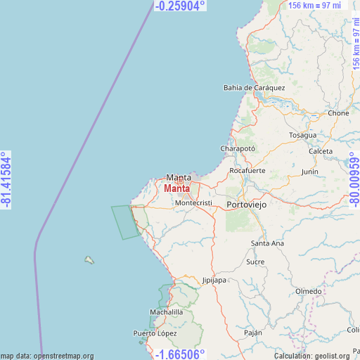
Manta GPS coordinates[2]
0° 57' 43.632" South, 80° 42' 45.756" West
| Map corner | latitude | longitude |
|---|---|---|
| Upper-left | -0.25904°, | -81.41584° |
| Center: | -0.96212°, | -80.71271° |
| Lower-right: | -1.66506°, | -80.00959° |
| Map W x H: | 156.3×156.3 km | = 97.1×97.1mi |
| max Lat: | 1.35251° ⇑34.7% North |
| Manta: | -0.96212° |
| min Lat: | ⇓65.3% South -4.38181° |
| min Long | Manta | max Long |
| -90.96654° | -80.71271° | -76.89528° |
| W 5%⇐ | ⇒95% E |
Elevation
Elevation of Manta is 23 m = 75 ft, and this is 922.1 m = 3025 ft below average elevation for this country.
| Max E: |
3131 m = 10272 ft | 74.4% |
| Avg. | 945.1 m = 3101 ft | |
| Manta | 23 m = 75 ft | |
Min E: |
1 m = 3 ft | 25.6% |
See also: Manta elevation on elevation.city.
Geographical zone
Manta is located in South Torrid zone (between Equator and Tropic of Capricorn). Distance of Equator is 107 km =66.5 mi to North.| Distance of | km | miles | from Manta |
|---|---|---|---|
| Equator | 107 | 66.5 | to North |
| Tropic Capricorn | 2498.9 | 1552.7 | to South |
| Antarctic Circle | 7294.2 | 4532.4 | to South |
| South Pole | 9900.1 | 6151.6 | to South |


Nearby cities:
15 places around Manta: (largest is in red/bold)
• Bahía de Caráquez
51.7 km =32.1 mi,  38°
38°
• Balzar
100.4 km =62.4 mi,  116°
116°
• Calceta
62.4 km =38.8 mi,  78°
78°
• Chone
74.8 km =46.5 mi,  66°
66°
• Colimes
101.4 km =63 mi,  129°
129°
• Jipijapa
45.5 km =28.3 mi,  160°
160°
• Junín
56.5 km =35.1 mi,  86°
86°
• Montecristi
11.1 km =6.9 mi,  147°
147°
• Paján
72.8 km =45.2 mi, 154°
• Portoviejo
30.5 km =19 mi,  109°
109°
• Rocafuerte
29.6 km =18.4 mi, 81°
• San Vicente
53.5 km =33.2 mi, 39°
• Santa Ana
46.7 km =29 mi, 125°
• Sucre
48.1 km =29.9 mi,  137°
137°
• Tosagua
56.6 km =35.2 mi, 69°
Sources, notices
• [Note1] Compared only with cities in Ecuador existing in our database
• [Src1] Map data: © OpenStreetMap contributors (CC-BY-SA)
• [Src2] Other city data from geonames.org with taken over terms of usage.
• [Src3] Geographical zone / Annual Mean Temperature by Robert A. Rohde @ Wikipedia
