Playas geodata
Playas (Guayas) is a populated place; located in Ecuador in America/Guayaquil (GMT-5) time zone. With population of 30,564 people, there are 40 cities with bigger population in this country. Compared to other cities in Ecuador, 79.3% of cities are located further ↑North; 87.6% of cities are located further →East and 87.6% of cities have higher elevation than Playas. Note1


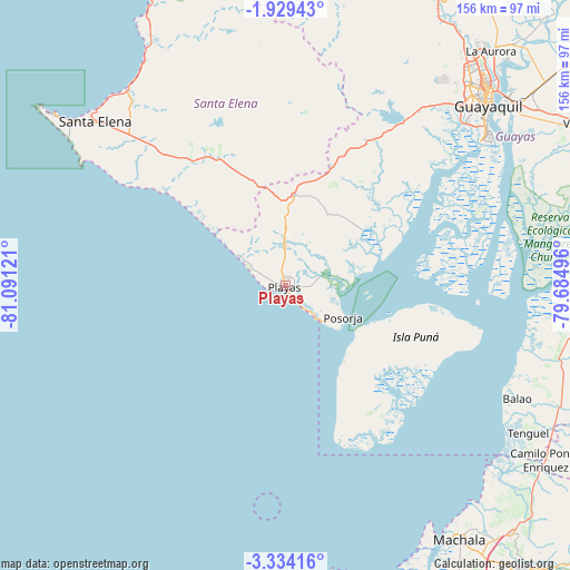
Playas GPS coordinates[2]
2° 37' 55.164" South, 80° 23' 17.088" West
| Map corner | latitude | longitude |
|---|---|---|
| Upper-left | -1.92943°, | -81.09121° |
| Center: | -2.63199°, | -80.38808° |
| Lower-right: | -3.33416°, | -79.68496° |
| Map W x H: | 156.2×156.2 km | = 97.1×97.1mi |
| max Lat: | 1.35251° ⇑79.3% North |
| Playas: | -2.63199° |
| min Lat: | ⇓20.7% South -4.38181° |
| min Long | Playas | max Long |
| -90.96654° | -80.38808° | -76.89528° |
| W 12.4%⇐ | ⇒87.6% E |
Elevation
Elevation of Playas is 10 m = 33 ft, and this is 935.1 m = 3068 ft below average elevation for this country.
| Max E: |
3131 m = 10272 ft | 87.6% |
| Avg. | 945.1 m = 3101 ft | |
| Playas | 10 m = 33 ft | |
Min E: |
1 m = 3 ft | 12.4% |
See also: Ecuador elevation on elevation.city.
Geographical zone
Playas is located in South Torrid zone (between Equator and Tropic of Capricorn). Distance of Equator is 292.6 km =181.8 mi to North.| Distance of | km | miles | from Playas |
|---|---|---|---|
| Equator | 292.6 | 181.8 | to North |
| Tropic Capricorn | 2313.3 | 1437.4 | to South |
| Antarctic Circle | 7108.5 | 4417 | to South |
| South Pole | 9714.4 | 6036.2 | to South |


Nearby cities:
15 places around Playas: (largest is in red/bold)
• Baláo
70.9 km =44.1 mi,  115°
115°
• El Triunfo
90.7 km =56.4 mi,  31°
31°
• Eloy Alfaro
78 km =48.5 mi,  49°
49°
• Guayaquil
73.9 km =45.9 mi, 49°
• Huaquillas
95.4 km =59.3 mi,  169°
169°
• La Libertad
73 km =45.4 mi,  307°
307°
• Lomas de Sargentillo
89.9 km =55.9 mi,  22°
22°
• Machala
84.3 km =52.4 mi,  145°
145°
• Naranjal
85.6 km =53.2 mi,  93°
93°
• Pedro Carbo
92.4 km =57.4 mi,  10°
10°
• Puerto Bolívar
82.8 km =51.4 mi, 148°
• Salinas
77.9 km =48.4 mi, 306°
• Santa Elena
69.1 km =42.9 mi, 310°
• Santa Lucía
65.9 km =40.9 mi,  40°
40°
• Yaguachi Nuevo
97.3 km =60.5 mi, 52°
Sources, notices
• [Note1] Compared only with cities in Ecuador existing in our database
• [Src1] Map data: © OpenStreetMap contributors (CC-BY-SA)
• [Src2] Other city data from geonames.org with taken over terms of usage.
• [Src3] Geographical zone / Annual Mean Temperature by Robert A. Rohde @ Wikipedia
