Machala geodata
Machala (El Oro) is a seat of a first-order administrative division; located in Ecuador in America/Guayaquil (GMT-5) time zone. With population of 198,123 people, there are 4 cities with bigger population in this country. Compared to other cities in Ecuador, 86.8% of cities are located further ↑North; 75.2% of cities are located further →East and 81.8% of cities have higher elevation than Machala. Note1


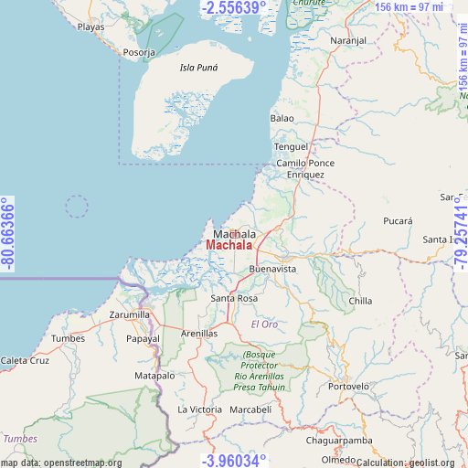
Machala GPS coordinates[2]
3° 15' 30.996" South, 79° 57' 37.908" West
| Map corner | latitude | longitude |
|---|---|---|
| Upper-left | -2.55639°, | -80.66366° |
| Center: | -3.25861°, | -79.96053° |
| Lower-right: | -3.96034°, | -79.25741° |
| Map W x H: | 156.1×156.1 km | = 97×97mi |
| max Lat: | 1.35251° ⇑86.8% North |
| Machala: | -3.25861° |
| min Lat: | ⇓13.2% South -4.38181° |
| min Long | Machala | max Long |
| -90.96654° | -79.96053° | -76.89528° |
| W 24.8%⇐ | ⇒75.2% E |
Elevation
Elevation of Machala is 15 m = 49 ft, and this is 930.1 m = 3052 ft below average elevation for this country.
| Max E: |
3131 m = 10272 ft | 81.8% |
| Avg. | 945.1 m = 3101 ft | |
| Machala | 15 m = 49 ft | |
Min E: |
1 m = 3 ft | 18.2% |
See also: Machala elevation on elevation.city.
Geographical zone
Machala is located in South Torrid zone (between Equator and Tropic of Capricorn). Distance of Equator is 362.3 km =225.1 mi to North.| Distance of | km | miles | from Machala |
|---|---|---|---|
| Equator | 362.3 | 225.1 | to North |
| Tropic Capricorn | 2243.6 | 1394.1 | to South |
| Antarctic Circle | 7038.9 | 4373.8 | to South |
| South Pole | 9644.7 | 5992.9 | to South |


Nearby cities:
15 places around Machala: (largest is in red/bold)
• Baláo
41.9 km =26 mi,  22°
22°
• Catacocha
94.5 km =58.7 mi,  158°
158°
• Catamayo
104.9 km =65.2 mi,  140°
140°
• Celica
93.9 km =58.3 mi,  179°
179°
• Cuenca
113.4 km =70.5 mi,  69°
69°
• Huaquillas
38.5 km =23.9 mi,  231°
231°
• La Troncal
115.6 km =71.8 mi,  36°
36°
• Naranjal
75.3 km =46.8 mi,  30°
30°
• Pasaje
18.6 km =11.6 mi,  113°
113°
• Piñas
56.3 km =35 mi,  146°
146°
• Playas
84.3 km =52.4 mi,  325°
325°
• Portovelo
63.7 km =39.6 mi, 143°
• Puerto Bolívar
4.2 km =2.6 mi,  257°
257°
• Santa Rosa
21.1 km =13.1 mi, 179°
• Zaruma
61.8 km =38.4 mi, 141°
Sources, notices
• [Note1] Compared only with cities in Ecuador existing in our database
• [Src1] Map data: © OpenStreetMap contributors (CC-BY-SA)
• [Src2] Other city data from geonames.org with taken over terms of usage.
• [Src3] Geographical zone / Annual Mean Temperature by Robert A. Rohde @ Wikipedia
