Puerto Bolívar geodata
Puerto Bolívar (El Oro) is a populated place; located in Ecuador in America/Guayaquil (GMT-5) time zone. With population of 8,300 people, there are 93 cities with bigger population in this country. Compared to other cities in Ecuador, 87.6% of cities are located further ↑North; 76.9% of cities are located further →East and 97.5% of cities have higher elevation than Puerto Bolívar. Note1


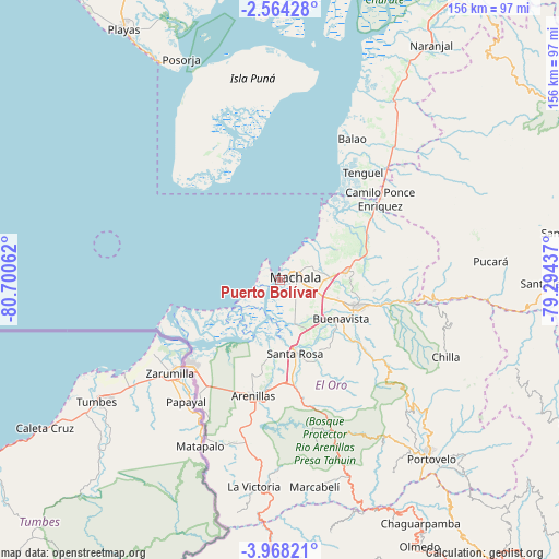
Puerto Bolívar GPS coordinates[2]
3° 15' 59.364" South, 79° 59' 50.964" West
| Map corner | latitude | longitude |
|---|---|---|
| Upper-left | -2.56428°, | -80.70062° |
| Center: | -3.26649°, | -79.99749° |
| Lower-right: | -3.96821°, | -79.29437° |
| Map W x H: | 156.1×156.1 km | = 97×97mi |
| max Lat: | 1.35251° ⇑87.6% North |
| Puerto Bolívar: | -3.26649° |
| min Lat: | ⇓12.4% South -4.38181° |
| min Long | Puerto Bolívar | max Long |
| -90.96654° | -79.99749° | -76.89528° |
| W 23.1%⇐ | ⇒76.9% E |
Elevation
Elevation of Puerto Bolívar is 6 m = 20 ft, and this is 939.1 m = 3081 ft below average elevation for this country.
| Max E: |
3131 m = 10272 ft | 97.5% |
| Avg. | 945.1 m = 3101 ft | |
| Puerto Bolívar | 6 m = 20 ft | |
Min E: |
1 m = 3 ft | 2.5% |
See also: Ecuador elevation on elevation.city.
Geographical zone
Puerto Bolívar is located in South Torrid zone (between Equator and Tropic of Capricorn). Distance of Equator is 363.2 km =225.7 mi to North.| Distance of | km | miles | from Puerto Bolívar |
|---|---|---|---|
| Equator | 363.2 | 225.7 | to North |
| Tropic Capricorn | 2242.7 | 1393.5 | to South |
| Antarctic Circle | 7038 | 4373.2 | to South |
| South Pole | 9643.9 | 5992.4 | to South |


Nearby cities:
15 places around Puerto Bolívar: (largest is in red/bold)
• Baláo
44.4 km =27.6 mi,  27°
27°
• Catacocha
95.3 km =59.2 mi,  156°
156°
• Catamayo
106.9 km =66.4 mi,  138°
138°
• Celica
93.1 km =57.8 mi,  177°
177°
• Cuenca
117.5 km =73 mi,  69°
69°
• Huaquillas
34.8 km =21.6 mi,  228°
228°
• La Troncal
118.8 km =73.8 mi,  37°
37°
• Machala
4.2 km =2.6 mi,  77°
77°
• Naranjal
78.2 km =48.6 mi, 32°
• Pasaje
22.1 km =13.7 mi,  107°
107°
• Piñas
58 km =36 mi, 142°
• Playas
82.8 km =51.4 mi,  328°
328°
• Portovelo
65.6 km =40.8 mi, 140°
• Santa Rosa
20.7 km =12.9 mi,  168°
168°
• Zaruma
63.8 km =39.6 mi, 137°
Sources, notices
• [Note1] Compared only with cities in Ecuador existing in our database
• [Src1] Map data: © OpenStreetMap contributors (CC-BY-SA)
• [Src2] Other city data from geonames.org with taken over terms of usage.
• [Src3] Geographical zone / Annual Mean Temperature by Robert A. Rohde @ Wikipedia
