Otavalo geodata
Otavalo (Imbabura) is a populated place; located in Ecuador in America/Guayaquil (GMT-5) time zone. With population of 32,330 people, there are 37 cities with bigger population in this country. Compared to other cities in Ecuador, 88.4% of cities are located further ↓South; 83.5% of cities are located further ←West and 82.6% of cities have lower elevation than Otavalo. Note1


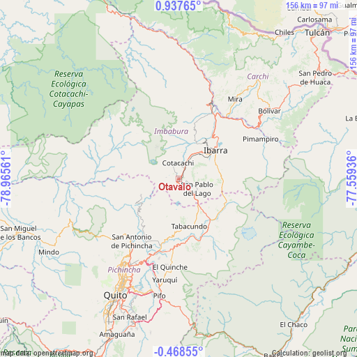
Otavalo GPS coordinates[2]
0° 14' 4.452" North, 78° 15' 44.928" West
| Map corner | latitude | longitude |
|---|---|---|
| Upper-left | 0.93765°, | -78.96561° |
| Center: | 0.23457°, | -78.26248° |
| Lower-right: | -0.46855°, | -77.55936° |
| Map W x H: | 156.4×156.4 km | = 97.2×97.2mi |
| max Lat: | 1.35251° ⇑11.6% North |
| Otavalo: | 0.23457° |
| min Lat: | ⇓88.4% South -4.38181° |
| min Long | Otavalo | max Long |
| -90.96654° | -78.26248° | -76.89528° |
| W 83.5%⇐ | ⇒16.5% E |
Elevation
Elevation of Otavalo is 2532 m = 8307 ft, and this is 1586.9 m = 5206 ft above average elevation for this country.
| Max E: |
3131 m = 10272 ft | 17.4% |
| Otavalo | 2532 m 8307 ft | |
| Avg. | 945.1 m = 3101 ft | |
Min E: |
1 m = 3 ft | 82.6% |
See also: Ecuador elevation on elevation.city.
Geographical zone
Otavalo is located in North Torrid zone (between Equator and Tropic of Cancer). Distance of Equator is 26.1 km =16.2 mi to South.| Distance of | km | miles | from Otavalo |
|---|---|---|---|
| North Pole | 9981 | 6201.9 | to North |
| Arctic Circle | 7375.1 | 4582.7 | to North |
| Tropic Cancer | 2579.8 | 1603 | to North |
| Equator | 26.1 | 16.2 | to South |


Nearby cities:
15 places around Otavalo: (largest is in red/bold)
• Atuntaqui
12.2 km =7.6 mi,  26°
26°
• Cayambe
25.2 km =15.7 mi,  148°
148°
• Cotacachi
7.4 km =4.6 mi,  358°
358°
• El Ángel
56.1 km =34.9 mi,  39°
39°
• Gonzalo Pizarro
101.1 km =62.8 mi,  103°
103°
• Ibarra
20.3 km =12.6 mi,  50°
50°
• Machachi
89.5 km =55.6 mi,  202°
202°
• Pimampiro
39.8 km =24.7 mi,  64°
64°
• Quito
59.3 km =36.8 mi,  209°
209°
• San Gabriel
62.4 km =38.8 mi, 50°
• Sangolquí
66.6 km =41.4 mi, 198°
• Santo Domingo de los Colorados
115.1 km =71.5 mi,  241°
241°
• Saquisilí
127.7 km =79.3 mi, 200°
• Tulcán
88.3 km =54.9 mi, 43°
• Tutamandahostel
54.7 km =34 mi, 208°
Sources, notices
• [Note1] Compared only with cities in Ecuador existing in our database
• [Src1] Map data: © OpenStreetMap contributors (CC-BY-SA)
• [Src2] Other city data from geonames.org with taken over terms of usage.
• [Src3] Geographical zone / Annual Mean Temperature by Robert A. Rohde @ Wikipedia
