San Gabriel geodata
San Gabriel (Carchi) is a populated place; located in Ecuador in America/Guayaquil (GMT-5) time zone. With population of 15,112 people, there are 66 cities with bigger population in this country. Compared to other cities in Ecuador, 94.2% of cities are located further ↓South; 92.6% of cities are located further ←West and 93.4% of cities have lower elevation than San Gabriel. Note1


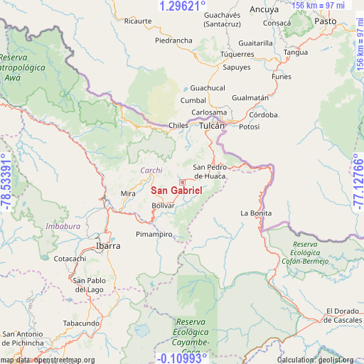
San Gabriel GPS coordinates[2]
0° 35' 35.448" North, 77° 49' 50.808" West
| Map corner | latitude | longitude |
|---|---|---|
| Upper-left | 1.29621°, | -78.53391° |
| Center: | 0.59318°, | -77.83078° |
| Lower-right: | -0.10993°, | -77.12766° |
| Map W x H: | 156.3×156.4 km | = 97.1×97.2mi |
| max Lat: | 1.35251° ⇑5.8% North |
| San Gabriel: | 0.59318° |
| min Lat: | ⇓94.2% South -4.38181° |
| min Long | San Gabriel | max Long |
| -90.96654° | -77.83078° | -76.89528° |
| W 92.6%⇐ | ⇒7.4% E |
Elevation
Elevation of San Gabriel is 2860 m = 9383 ft, and this is 1914.9 m = 6282 ft above average elevation for this country.
| Max E: |
3131 m = 10272 ft | 6.6% |
| San Gabriel | 2860 m 9383 ft | |
| Avg. | 945.1 m = 3101 ft | |
Min E: |
1 m = 3 ft | 93.4% |
See also: Ecuador elevation on elevation.city.
Geographical zone
San Gabriel is located in North Torrid zone (between Equator and Tropic of Cancer). Distance of Equator is 66 km =41 mi to South.| Distance of | km | miles | from San Gabriel |
|---|---|---|---|
| North Pole | 9941.1 | 6177.1 | to North |
| Arctic Circle | 7335.2 | 4557.9 | to North |
| Tropic Cancer | 2540 | 1578.3 | to North |
| Equator | 66 | 41 | to South |


Nearby cities:
15 places around San Gabriel: (largest is in red/bold)
• Atuntaqui
51.5 km =32 mi,  235°
235°
• Cayambe
70.7 km =43.9 mi,  209°
209°
• Cotacachi
58.1 km =36.1 mi, 236°
• El Ángel
12.6 km =7.8 mi,  285°
285°
• Gonzalo Pizarro
81.4 km =50.6 mi,  141°
141°
• Ibarra
42.1 km =26.2 mi,  230°
230°
• Nueva Loja
118.3 km =73.5 mi,  118°
118°
• Otavalo
62.4 km =38.8 mi, 230°
• Pampanal de Bolívar
145.2 km =90.2 mi,  305°
305°
• Pimampiro
25.6 km =15.9 mi, 208°
• Quito
119.7 km =74.4 mi,  220°
220°
• San Lorenzo de Esmeraldas
135.7 km =84.3 mi,  304°
304°
• Sangolquí
124.1 km =77.1 mi, 213°
• Tulcán
27.4 km =17 mi,  27°
27°
• Tutamandahostel
115 km =71.5 mi, 220°
Sources, notices
• [Note1] Compared only with cities in Ecuador existing in our database
• [Src1] Map data: © OpenStreetMap contributors (CC-BY-SA)
• [Src2] Other city data from geonames.org with taken over terms of usage.
• [Src3] Geographical zone / Annual Mean Temperature by Robert A. Rohde @ Wikipedia
