Sangolquí geodata
Sangolquí (Pichincha) is a populated place; located in Ecuador in America/Guayaquil (GMT-5) time zone. With population of 5,114 people, there are 104 cities with bigger population in this country. Compared to other cities in Ecuador, 81.8% of cities are located further ↓South; 81% of cities are located further ←West and 81% of cities have lower elevation than Sangolquí. Note1


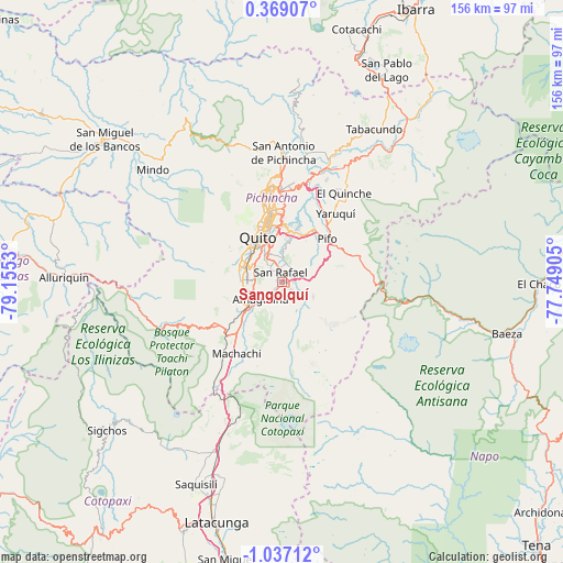
Sangolquí GPS coordinates[2]
0° 20' 2.58" South, 78° 27' 7.812" West
| Map corner | latitude | longitude |
|---|---|---|
| Upper-left | 0.36907°, | -79.1553° |
| Center: | -0.33405°, | -78.45217° |
| Lower-right: | -1.03712°, | -77.74905° |
| Map W x H: | 156.4×156.4 km | = 97.2×97.2mi |
| max Lat: | 1.35251° ⇑18.2% North |
| Sangolquí: | -0.33405° |
| min Lat: | ⇓81.8% South -4.38181° |
| min Long | Sangolquí | max Long |
| -90.96654° | -78.45217° | -76.89528° |
| W 81%⇐ | ⇒19% E |
Elevation
Elevation of Sangolquí is 2513 m = 8245 ft, and this is 1567.9 m = 5144 ft above average elevation for this country.
| Max E: |
3131 m = 10272 ft | 19% |
| Sangolquí | 2513 m 8245 ft | |
| Avg. | 945.1 m = 3101 ft | |
Min E: |
1 m = 3 ft | 81% |
See also: Ecuador elevation on elevation.city.
Geographical zone
Sangolquí is located in South Torrid zone (between Equator and Tropic of Capricorn). Distance of Equator is 37.1 km =23.1 mi to North.| Distance of | km | miles | from Sangolquí |
|---|---|---|---|
| Equator | 37.1 | 23.1 | to North |
| Tropic Capricorn | 2568.8 | 1596.2 | to South |
| Antarctic Circle | 7364 | 4575.8 | to South |
| South Pole | 9969.9 | 6195 | to South |


Nearby cities:
15 places around Sangolquí: (largest is in red/bold)
• Archidona
96.1 km =59.7 mi,  131°
131°
• Atuntaqui
78.7 km =48.9 mi,  19°
19°
• Cayambe
53.9 km =33.5 mi,  39°
39°
• Cotacachi
73.6 km =45.7 mi, 16°
• Ibarra
84.6 km =52.6 mi,  25°
25°
• Latacunga
69.3 km =43.1 mi,  195°
195°
• Machachi
23.4 km =14.5 mi,  213°
213°
• Otavalo
66.6 km =41.4 mi, 18°
• Pujilí
74.5 km =46.3 mi, 201°
• Píllaro
94 km =58.4 mi,  186°
186°
• Quito
14.1 km =8.8 mi,  325°
325°
• San Miguel de Salcedo
80.6 km =50.1 mi, 191°
• Santo Domingo de los Colorados
80.9 km =50.3 mi,  276°
276°
• Saquisilí
61.1 km =38 mi, 203°
• Tutamandahostel
16 km =9.9 mi,  341°
341°
Sources, notices
• [Note1] Compared only with cities in Ecuador existing in our database
• [Src1] Map data: © OpenStreetMap contributors (CC-BY-SA)
• [Src2] Other city data from geonames.org with taken over terms of usage.
• [Src3] Geographical zone / Annual Mean Temperature by Robert A. Rohde @ Wikipedia
