Ibarra geodata
Ibarra (Imbabura) is a seat of a first-order administrative division; located in Ecuador in America/Guayaquil (GMT-5) time zone. With population of 132,977 people, there are 12 cities with bigger population in this country. Compared to other cities in Ecuador, 91.7% of cities are located further ↓South; 86.8% of cities are located further ←West and 74.4% of cities have lower elevation than Ibarra. Note1


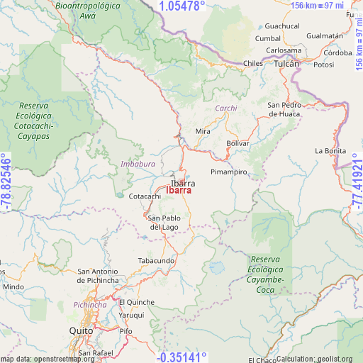
Ibarra GPS coordinates[2]
0° 21' 6.156" North, 78° 7' 20.388" West
| Map corner | latitude | longitude |
|---|---|---|
| Upper-left | 1.05478°, | -78.82546° |
| Center: | 0.35171°, | -78.12233° |
| Lower-right: | -0.35141°, | -77.41921° |
| Map W x H: | 156.4×156.4 km | = 97.2×97.2mi |
| max Lat: | 1.35251° ⇑8.3% North |
| Ibarra: | 0.35171° |
| min Lat: | ⇓91.7% South -4.38181° |
| min Long | Ibarra | max Long |
| -90.96654° | -78.12233° | -76.89528° |
| W 86.8%⇐ | ⇒13.2% E |
Elevation
Elevation of Ibarra is 2208 m = 7244 ft, and this is 1262.9 m = 4143 ft above average elevation for this country.
| Max E: |
3131 m = 10272 ft | 25.6% |
| Ibarra | 2208 m 7244 ft | |
| Avg. | 945.1 m = 3101 ft | |
Min E: |
1 m = 3 ft | 74.4% |
See also: Ibarra elevation on elevation.city.
Geographical zone
Ibarra is located in North Torrid zone (between Equator and Tropic of Cancer). Distance of Equator is 39.1 km =24.3 mi to South.| Distance of | km | miles | from Ibarra |
|---|---|---|---|
| North Pole | 9968 | 6193.8 | to North |
| Arctic Circle | 7362.1 | 4574.6 | to North |
| Tropic Cancer | 2566.8 | 1594.9 | to North |
| Equator | 39.1 | 24.3 | to South |


Nearby cities:
15 places around Ibarra: (largest is in red/bold)
• Atuntaqui
10.4 km =6.5 mi,  258°
258°
• Cayambe
34.7 km =21.6 mi,  184°
184°
• Cotacachi
16.8 km =10.4 mi,  250°
250°
• El Ángel
36.3 km =22.6 mi,  33°
33°
• Gonzalo Pizarro
90.6 km =56.3 mi,  114°
114°
• Machachi
107.8 km =67 mi,  207°
207°
• Otavalo
20.3 km =12.6 mi,  230°
230°
• Pimampiro
20.7 km =12.9 mi,  77°
77°
• Quito
78.6 km =48.8 mi, 214°
• San Gabriel
42.1 km =26.2 mi,  50°
50°
• San Lorenzo de Esmeraldas
130.7 km =81.2 mi,  322°
322°
• Sangolquí
84.6 km =52.6 mi, 205°
• Santo Domingo de los Colorados
135 km =83.9 mi,  240°
240°
• Tulcán
68.2 km =42.4 mi,  41°
41°
• Tutamandahostel
73.9 km =45.9 mi, 214°
Sources, notices
• [Note1] Compared only with cities in Ecuador existing in our database
• [Src1] Map data: © OpenStreetMap contributors (CC-BY-SA)
• [Src2] Other city data from geonames.org with taken over terms of usage.
• [Src3] Geographical zone / Annual Mean Temperature by Robert A. Rohde @ Wikipedia
