Atuntaqui geodata
Atuntaqui (Imbabura) is a populated place; located in Ecuador in America/Guayaquil (GMT-5) time zone. With population of 17,456 people, there are 54 cities with bigger population in this country. Compared to other cities in Ecuador, 90.9% of cities are located further ↓South; 84.3% of cities are located further ←West and 76.9% of cities have lower elevation than Atuntaqui. Note1


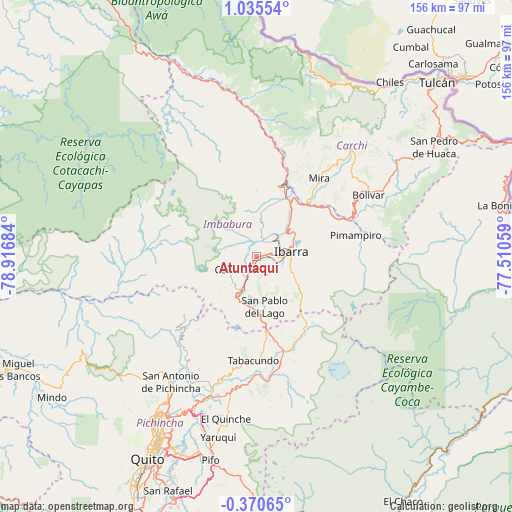
Atuntaqui GPS coordinates[2]
0° 19' 56.892" North, 78° 12' 49.356" West
| Map corner | latitude | longitude |
|---|---|---|
| Upper-left | 1.03554°, | -78.91684° |
| Center: | 0.33247°, | -78.21371° |
| Lower-right: | -0.37065°, | -77.51059° |
| Map W x H: | 156.4×156.4 km | = 97.2×97.2mi |
| max Lat: | 1.35251° ⇑9.1% North |
| Atuntaqui: | 0.33247° |
| min Lat: | ⇓90.9% South -4.38181° |
| min Long | Atuntaqui | max Long |
| -90.96654° | -78.21371° | -76.89528° |
| W 84.3%⇐ | ⇒15.7% E |
Elevation
Elevation of Atuntaqui is 2413 m = 7917 ft, and this is 1467.9 m = 4816 ft above average elevation for this country.
| Max E: |
3131 m = 10272 ft | 23.1% |
| Atuntaqui | 2413 m 7917 ft | |
| Avg. | 945.1 m = 3101 ft | |
Min E: |
1 m = 3 ft | 76.9% |
See also: Ecuador elevation on elevation.city.
Geographical zone
Atuntaqui is located in North Torrid zone (between Equator and Tropic of Cancer). Distance of Equator is 37 km =23 mi to South.| Distance of | km | miles | from Atuntaqui |
|---|---|---|---|
| North Pole | 9970.1 | 6195.1 | to North |
| Arctic Circle | 7364.2 | 4575.9 | to North |
| Tropic Cancer | 2569 | 1596.3 | to North |
| Equator | 37 | 23 | to South |


Nearby cities:
15 places around Atuntaqui: (largest is in red/bold)
• Cayambe
33.3 km =20.7 mi,  166°
166°
• Cotacachi
6.6 km =4.1 mi,  238°
238°
• El Ángel
44.4 km =27.6 mi,  43°
43°
• Gonzalo Pizarro
99.2 km =61.6 mi,  110°
110°
• Ibarra
10.4 km =6.5 mi,  78°
78°
• Machachi
101.6 km =63.1 mi,  202°
202°
• Otavalo
12.2 km =7.6 mi,  206°
206°
• Pimampiro
31.1 km =19.3 mi, 77°
• Quito
71.5 km =44.4 mi, 208°
• San Gabriel
51.5 km =32 mi,  55°
55°
• San Lorenzo de Esmeraldas
126.6 km =78.7 mi,  326°
326°
• Sangolquí
78.7 km =48.9 mi, 199°
• Santo Domingo de los Colorados
125.2 km =77.8 mi, 238°
• Tulcán
76.7 km =47.7 mi,  45°
45°
• Tutamandahostel
66.8 km =41.5 mi, 208°
Sources, notices
• [Note1] Compared only with cities in Ecuador existing in our database
• [Src1] Map data: © OpenStreetMap contributors (CC-BY-SA)
• [Src2] Other city data from geonames.org with taken over terms of usage.
• [Src3] Geographical zone / Annual Mean Temperature by Robert A. Rohde @ Wikipedia
