Cayambe geodata
Cayambe (Pichincha) is a populated place; located in Ecuador in America/Guayaquil (GMT-5) time zone. With population of 26,582 people, there are 42 cities with bigger population in this country. Compared to other cities in Ecuador, 86% of cities are located further ↓South; 86% of cities are located further ←West and 91.7% of cities have lower elevation than Cayambe. Note1


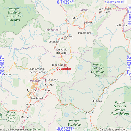
Cayambe GPS coordinates[2]
0° 2' 27.024" North, 78° 8' 42.864" West
| Map corner | latitude | longitude |
|---|---|---|
| Upper-left | 0.74394°, | -78.84837° |
| Center: | 0.04084°, | -78.14524° |
| Lower-right: | -0.66227°, | -77.44212° |
| Map W x H: | 156.4×156.4 km | = 97.2×97.2mi |
| max Lat: | 1.35251° ⇑14% North |
| Cayambe: | 0.04084° |
| min Lat: | ⇓86% South -4.38181° |
| min Long | Cayambe | max Long |
| -90.96654° | -78.14524° | -76.89528° |
| W 86%⇐ | ⇒14% E |
Elevation
Elevation of Cayambe is 2814 m = 9232 ft, and this is 1868.9 m = 6132 ft above average elevation for this country.
| Max E: |
3131 m = 10272 ft | 8.3% |
| Cayambe | 2814 m 9232 ft | |
| Avg. | 945.1 m = 3101 ft | |
Min E: |
1 m = 3 ft | 91.7% |
See also: Ecuador elevation on elevation.city.
Geographical zone
Cayambe is located in North Torrid zone (between Equator and Tropic of Cancer). Distance of Equator is 4.5 km =2.8 mi to South.| Distance of | km | miles | from Cayambe |
|---|---|---|---|
| North Pole | 10002.5 | 6215.3 | to North |
| Arctic Circle | 7396.6 | 4596 | to North |
| Tropic Cancer | 2601.4 | 1616.4 | to North |
| Equator | 4.5 | 2.8 | to South |


Nearby cities:
15 places around Cayambe: (largest is in red/bold)
• Archidona
112.1 km =69.7 mi,  160°
160°
• Atuntaqui
33.3 km =20.7 mi,  346°
346°
• Cotacachi
31.8 km =19.8 mi,  335°
335°
• El Ángel
68.6 km =42.6 mi,  19°
19°
• Gonzalo Pizarro
85.2 km =52.9 mi,  91°
91°
• Ibarra
34.7 km =21.6 mi,  4°
4°
• Machachi
77.2 km =48 mi,  217°
217°
• Otavalo
25.2 km =15.7 mi,  328°
328°
• Pimampiro
45.1 km =28 mi,  30°
30°
• Quito
51.8 km =32.2 mi,  234°
234°
• San Gabriel
70.7 km =43.9 mi, 29°
• Sangolquí
53.9 km =33.5 mi, 219°
• Saquisilí
113.8 km =70.7 mi,  210°
210°
• Tulcán
98.1 km =61 mi, 29°
• Tutamandahostel
47.3 km =29.4 mi,  235°
235°
Sources, notices
• [Note1] Compared only with cities in Ecuador existing in our database
• [Src1] Map data: © OpenStreetMap contributors (CC-BY-SA)
• [Src2] Other city data from geonames.org with taken over terms of usage.
• [Src3] Geographical zone / Annual Mean Temperature by Robert A. Rohde @ Wikipedia
