Machachi geodata
Machachi (Pichincha) is a populated place; located in Ecuador in America/Guayaquil (GMT-5) time zone. With population of 25,742 people, there are 43 cities with bigger population in this country. Compared to other cities in Ecuador, 79.3% of cities are located further ↓South; 76.9% of cities are located further ←West and 95% of cities have lower elevation than Machachi. Note1


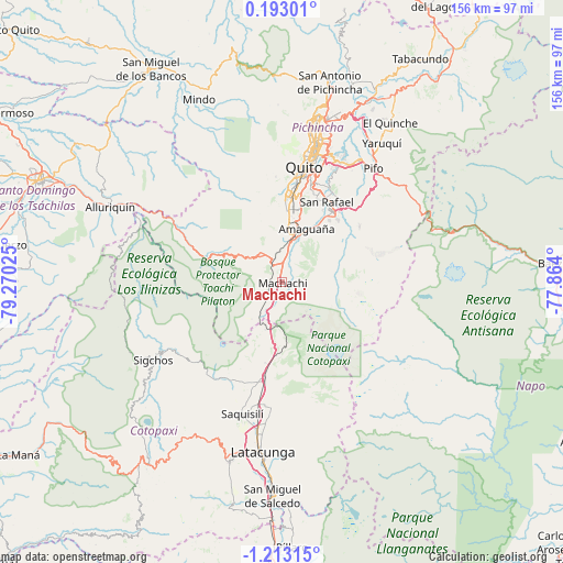
Machachi GPS coordinates[2]
0° 30' 36.396" South, 78° 34' 1.632" West
| Map corner | latitude | longitude |
|---|---|---|
| Upper-left | 0.19301°, | -79.27025° |
| Center: | -0.51011°, | -78.56712° |
| Lower-right: | -1.21315°, | -77.864° |
| Map W x H: | 156.4×156.4 km | = 97.2×97.2mi |
| max Lat: | 1.35251° ⇑20.7% North |
| Machachi: | -0.51011° |
| min Lat: | ⇓79.3% South -4.38181° |
| min Long | Machachi | max Long |
| -90.96654° | -78.56712° | -76.89528° |
| W 76.9%⇐ | ⇒23.1% E |
Elevation
Elevation of Machachi is 2933 m = 9623 ft, and this is 1987.9 m = 6522 ft above average elevation for this country.
| Max E: |
3131 m = 10272 ft | 5% |
| Machachi | 2933 m 9623 ft | |
| Avg. | 945.1 m = 3101 ft | |
Min E: |
1 m = 3 ft | 95% |
See also: Ecuador elevation on elevation.city.
Geographical zone
Machachi is located in South Torrid zone (between Equator and Tropic of Capricorn). Distance of Equator is 56.7 km =35.2 mi to North.| Distance of | km | miles | from Machachi |
|---|---|---|---|
| Equator | 56.7 | 35.2 | to North |
| Tropic Capricorn | 2549.2 | 1584 | to South |
| Antarctic Circle | 7344.5 | 4563.7 | to South |
| South Pole | 9950.3 | 6182.8 | to South |


Nearby cities:
15 places around Machachi: (largest is in red/bold)
• Ambato
82.4 km =51.2 mi,  183°
183°
• Archidona
95.4 km =59.3 mi,  117°
117°
• Cayambe
77.2 km =48 mi,  37°
37°
• La Maná
87.4 km =54.3 mi,  236°
236°
• Latacunga
47.6 km =29.6 mi,  186°
186°
• Otavalo
89.5 km =55.6 mi,  22°
22°
• Pelileo
91.2 km =56.7 mi, 178°
• Pujilí
51.8 km =32.2 mi,  196°
196°
• Píllaro
73.9 km =45.9 mi, 178°
• Quito
31.5 km =19.6 mi,  8°
8°
• San Miguel de Salcedo
59.6 km =37 mi, 182°
• Sangolquí
23.4 km =14.5 mi,  33°
33°
• Santo Domingo de los Colorados
73.4 km =45.6 mi,  292°
292°
• Saquisilí
38.3 km =23.8 mi, 196°
• Tutamandahostel
35.6 km =22.1 mi, 12°
Sources, notices
• [Note1] Compared only with cities in Ecuador existing in our database
• [Src1] Map data: © OpenStreetMap contributors (CC-BY-SA)
• [Src2] Other city data from geonames.org with taken over terms of usage.
• [Src3] Geographical zone / Annual Mean Temperature by Robert A. Rohde @ Wikipedia
