Tulcán geodata
Tulcán (Carchi) is a seat of a first-order administrative division; located in Ecuador in America/Guayaquil (GMT-5) time zone. With population of 86,498 people, there are 16 cities with bigger population in this country. Compared to other cities in Ecuador, 96.7% of cities are located further ↓South; 95% of cities are located further ←West and 96.7% of cities have lower elevation than Tulcán. Note1


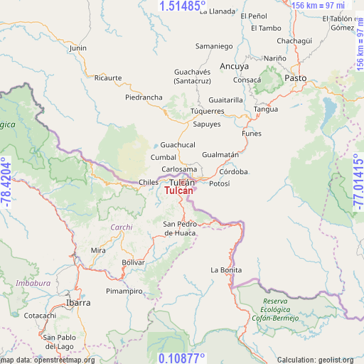
Tulcán GPS coordinates[2]
0° 48' 42.732" North, 77° 43' 2.172" West
| Map corner | latitude | longitude |
|---|---|---|
| Upper-left | 1.51485°, | -78.4204° |
| Center: | 0.81187°, | -77.71727° |
| Lower-right: | 0.10877°, | -77.01415° |
| Map W x H: | 156.3×156.3 km | = 97.1×97.1mi |
| max Lat: | 1.35251° ⇑3.3% North |
| Tulcán: | 0.81187° |
| min Lat: | ⇓96.7% South -4.38181° |
| min Long | Tulcán | max Long |
| -90.96654° | -77.71727° | -76.89528° |
| W 95%⇐ | ⇒5% E |
Elevation
Elevation of Tulcán is 2962 m = 9718 ft, and this is 2016.9 m = 6617 ft above average elevation for this country.
| Max E: |
3131 m = 10272 ft | 3.3% |
| Tulcán | 2962 m 9718 ft | |
| Avg. | 945.1 m = 3101 ft | |
Min E: |
1 m = 3 ft | 96.7% |
See also: Tulcán elevation on elevation.city.
Geographical zone
Tulcán is located in North Torrid zone (between Equator and Tropic of Cancer). Distance of Equator is 90.3 km =56.1 mi to South.| Distance of | km | miles | from Tulcán |
|---|---|---|---|
| North Pole | 9916.8 | 6162 | to North |
| Arctic Circle | 7310.9 | 4542.8 | to North |
| Tropic Cancer | 2515.6 | 1563.1 | to North |
| Equator | 90.3 | 56.1 | to South |


Nearby cities:
15 places around Tulcán: (largest is in red/bold)
• Atuntaqui
76.7 km =47.7 mi,  225°
225°
• Cayambe
98.1 km =61 mi,  209°
209°
• Cotacachi
83.2 km =51.7 mi, 226°
• El Ángel
32.5 km =20.2 mi, 229°
• Gonzalo Pizarro
96.1 km =59.7 mi,  156°
156°
• Ibarra
68.2 km =42.4 mi,  221°
221°
• Nueva Loja
121.9 km =75.7 mi,  131°
131°
• Otavalo
88.3 km =54.9 mi, 223°
• Pampanal de Bolívar
143.9 km =89.4 mi,  294°
294°
• Pimampiro
53 km =32.9 mi, 207°
• Quito
146.6 km =91.1 mi, 217°
• San Gabriel
27.4 km =17 mi, 207°
• San Lorenzo de Esmeraldas
135 km =83.9 mi, 292°
• Tutamandahostel
141.8 km =88.1 mi, 217°
• Valdez
148.9 km =92.5 mi, 289°
Sources, notices
• [Note1] Compared only with cities in Ecuador existing in our database
• [Src1] Map data: © OpenStreetMap contributors (CC-BY-SA)
• [Src2] Other city data from geonames.org with taken over terms of usage.
• [Src3] Geographical zone / Annual Mean Temperature by Robert A. Rohde @ Wikipedia
