Cañar geodata
Cañar is a populated place; located in Ecuador in America/Guayaquil (GMT-5) time zone. With population of 9,900 people, there are 83 cities with bigger population in this country. Compared to other cities in Ecuador, 78.5% of cities are located further ↑North; 61.2% of cities are located further ←West and 100% of cities have lower elevation than Cañar. Note1


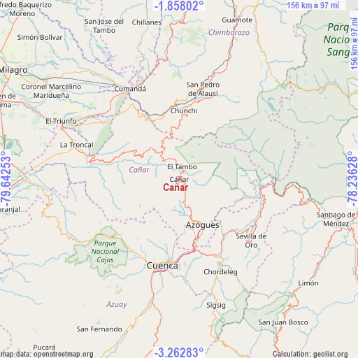
Cañar GPS coordinates[2]
2° 33' 38.232" South, 78° 56' 21.84" West
| Map corner | latitude | longitude |
|---|---|---|
| Upper-left | -1.85802°, | -79.64253° |
| Center: | -2.56062°, | -78.9394° |
| Lower-right: | -3.26283°, | -78.23628° |
| Map W x H: | 156.2×156.2 km | = 97.1×97.1mi |
| max Lat: | 1.35251° ⇑78.5% North |
| Cañar: | -2.56062° |
| min Lat: | ⇓21.5% South -4.38181° |
| min Long | Cañar | max Long |
| -90.96654° | -78.9394° | -76.89528° |
| W 61.2%⇐ | ⇒38.8% E |
Elevation
Elevation of Cañar is 3131 m = 10272 ft, and this is 2185.9 m = 7172 ft above average elevation for this country.
| Max E: |
3131 m = 10272 ft | 0% |
| Cañar | 3131 m 10272 ft | |
| Avg. | 945.1 m = 3101 ft | |
Min E: |
1 m = 3 ft | 100% |
See also: Ecuador elevation on elevation.city.
Geographical zone
Cañar is located in South Torrid zone (between Equator and Tropic of Capricorn). Distance of Equator is 284.7 km =176.9 mi to North.| Distance of | km | miles | from Cañar |
|---|---|---|---|
| Equator | 284.7 | 176.9 | to North |
| Tropic Capricorn | 2321.2 | 1442.3 | to South |
| Antarctic Circle | 7116.5 | 4422 | to South |
| South Pole | 9722.3 | 6041.2 | to South |


Nearby cities:
15 places around Cañar: (largest is in red/bold)
• Alausí
41 km =25.5 mi,  14°
14°
• Azogues
22.3 km =13.9 mi,  153°
153°
• Coronel Marcelino Maridueña
67.3 km =41.8 mi,  305°
305°
• Cuenca
38.5 km =23.9 mi,  190°
190°
• Gualaceo
41 km =25.5 mi, 154°
• La Troncal
47 km =29.2 mi,  288°
288°
• La Unión
36.5 km =22.7 mi, 151°
• Llacao
34.6 km =21.5 mi,  169°
169°
• Milagro
86.8 km =53.9 mi,  303°
303°
• Montalvo
94 km =58.4 mi,  335°
335°
• Naranjal
76.4 km =47.5 mi,  260°
260°
• Naranjito
73 km =45.4 mi, 306°
• Nulti
40.8 km =25.4 mi, 165°
• San Miguel
95.4 km =59.3 mi,  353°
353°
• Sucúa
86 km =53.4 mi,  82°
82°
Sources, notices
• [Note1] Compared only with cities in Ecuador existing in our database
• [Src1] Map data: © OpenStreetMap contributors (CC-BY-SA)
• [Src2] Other city data from geonames.org with taken over terms of usage.
• [Src3] Geographical zone / Annual Mean Temperature by Robert A. Rohde @ Wikipedia
