Cuenca geodata
Cuenca (Azuay) is a seat of a first-order administrative division; located in Ecuador in America/Guayaquil (GMT-5) time zone. With population of 276,964 people, there are 2 cities with bigger population in this country. Compared to other cities in Ecuador, 84.3% of cities are located further ↑North; 57.9% of cities are located further ←West and 83.5% of cities have lower elevation than Cuenca. Note1


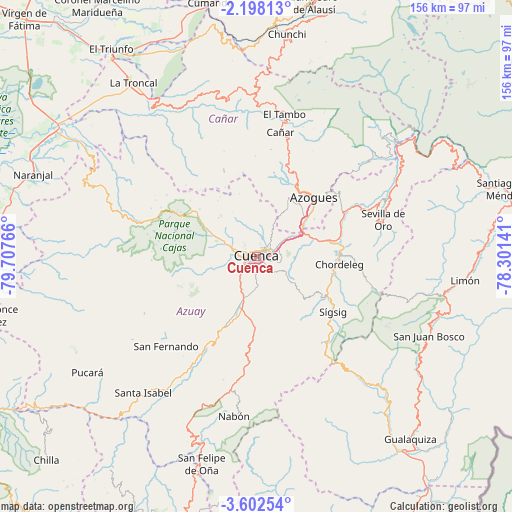
Cuenca GPS coordinates[2]
2° 54' 1.98" South, 79° 0' 16.308" West
| Map corner | latitude | longitude |
|---|---|---|
| Upper-left | -2.19813°, | -79.70766° |
| Center: | -2.90055°, | -79.00453° |
| Lower-right: | -3.60254°, | -78.30141° |
| Map W x H: | 156.2×156.2 km | = 97.1×97.1mi |
| max Lat: | 1.35251° ⇑84.3% North |
| Cuenca: | -2.90055° |
| min Lat: | ⇓15.7% South -4.38181° |
| min Long | Cuenca | max Long |
| -90.96654° | -79.00453° | -76.89528° |
| W 57.9%⇐ | ⇒42.1% E |
Elevation
Elevation of Cuenca is 2543 m = 8343 ft, and this is 1597.9 m = 5242 ft above average elevation for this country.
| Max E: |
3131 m = 10272 ft | 16.5% |
| Cuenca | 2543 m 8343 ft | |
| Avg. | 945.1 m = 3101 ft | |
Min E: |
1 m = 3 ft | 83.5% |
See also: Cuenca elevation on elevation.city.
Geographical zone
Cuenca is located in South Torrid zone (between Equator and Tropic of Capricorn). Distance of Equator is 322.5 km =200.4 mi to North.| Distance of | km | miles | from Cuenca |
|---|---|---|---|
| Equator | 322.5 | 200.4 | to North |
| Tropic Capricorn | 2283.4 | 1418.8 | to South |
| Antarctic Circle | 7078.7 | 4398.5 | to South |
| South Pole | 9684.6 | 6017.7 | to South |


Nearby cities:
15 places around Cuenca: (largest is in red/bold)
• Alausí
79.5 km =49.4 mi,  12°
12°
• Azogues
24.9 km =15.5 mi,  44°
44°
• Baláo
89.9 km =55.9 mi,  269°
269°
• Cañar
38.5 km =23.9 mi, 10°
• Coronel Marcelino Maridueña
90.4 km =56.2 mi,  328°
328°
• Gualaceo
25.2 km =15.7 mi,  87°
87°
• Gualaquiza
73 km =45.4 mi,  139°
139°
• La Troncal
64.8 km =40.3 mi,  324°
324°
• La Unión
25.2 km =15.7 mi,  77°
77°
• Llacao
14 km =8.7 mi,  74°
74°
• Naranjal
72.7 km =45.2 mi,  290°
290°
• Naranjito
96.3 km =59.8 mi, 327°
• Nulti
17.3 km =10.7 mi,  95°
95°
• Pasaje
100.9 km =62.7 mi,  242°
242°
• Sucúa
104.7 km =65.1 mi,  62°
62°
Sources, notices
• [Note1] Compared only with cities in Ecuador existing in our database
• [Src1] Map data: © OpenStreetMap contributors (CC-BY-SA)
• [Src2] Other city data from geonames.org with taken over terms of usage.
• [Src3] Geographical zone / Annual Mean Temperature by Robert A. Rohde @ Wikipedia
