Pasaje geodata
Pasaje (El Oro) is a populated place; located in Ecuador in America/Guayaquil (GMT-5) time zone. With population of 44,860 people, there are 23 cities with bigger population in this country. Compared to other cities in Ecuador, 88.4% of cities are located further ↑North; 68.6% of cities are located further →East and 67.8% of cities have higher elevation than Pasaje. Note1


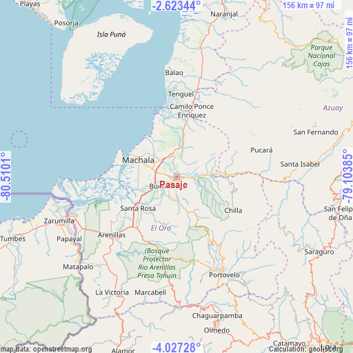
Pasaje GPS coordinates[2]
3° 19' 32.196" South, 79° 48' 25.092" West
| Map corner | latitude | longitude |
|---|---|---|
| Upper-left | -2.62344°, | -80.5101° |
| Center: | -3.32561°, | -79.80697° |
| Lower-right: | -4.02728°, | -79.10385° |
| Map W x H: | 156.1×156.1 km | = 97×97mi |
| max Lat: | 1.35251° ⇑88.4% North |
| Pasaje: | -3.32561° |
| min Lat: | ⇓11.6% South -4.38181° |
| min Long | Pasaje | max Long |
| -90.96654° | -79.80697° | -76.89528° |
| W 31.4%⇐ | ⇒68.6% E |
Elevation
Elevation of Pasaje is 30 m = 98 ft, and this is 915.1 m = 3002 ft below average elevation for this country.
| Max E: |
3131 m = 10272 ft | 67.8% |
| Avg. | 945.1 m = 3101 ft | |
| Pasaje | 30 m = 98 ft | |
Min E: |
1 m = 3 ft | 32.2% |
See also: Pasaje elevation on elevation.city.
Geographical zone
Pasaje is located in South Torrid zone (between Equator and Tropic of Capricorn). Distance of Equator is 369.8 km =229.8 mi to North.| Distance of | km | miles | from Pasaje |
|---|---|---|---|
| Equator | 369.8 | 229.8 | to North |
| Tropic Capricorn | 2236.1 | 1389.4 | to South |
| Antarctic Circle | 7031.4 | 4369.1 | to South |
| South Pole | 9637.3 | 5988.3 | to South |


Nearby cities:
15 places around Pasaje: (largest is in red/bold)
• Baláo
46.1 km =28.6 mi,  358°
358°
• Catacocha
82.4 km =51.2 mi,  167°
167°
• Catamayo
88.7 km =55.1 mi,  145°
145°
• Celica
88 km =54.7 mi,  190°
190°
• Cuenca
100.9 km =62.7 mi,  62°
62°
• Huaquillas
49.9 km =31 mi,  250°
250°
• Loja
99.9 km =62.1 mi,  137°
137°
• Machala
18.6 km =11.6 mi,  293°
293°
• Naranjal
75.5 km =46.9 mi,  16°
16°
• Piñas
41.9 km =26 mi,  160°
160°
• Playas
100.6 km =62.5 mi,  320°
320°
• Portovelo
48.6 km =30.2 mi, 154°
• Puerto Bolívar
22.1 km =13.7 mi, 287°
• Santa Rosa
21.8 km =13.5 mi,  231°
231°
• Zaruma
46.1 km =28.6 mi, 151°
Sources, notices
• [Note1] Compared only with cities in Ecuador existing in our database
• [Src1] Map data: © OpenStreetMap contributors (CC-BY-SA)
• [Src2] Other city data from geonames.org with taken over terms of usage.
• [Src3] Geographical zone / Annual Mean Temperature by Robert A. Rohde @ Wikipedia
