Montalvo geodata
Montalvo (Los Ríos) is a populated place; located in Ecuador in America/Guayaquil (GMT-5) time zone. With population of 15,547 people, there are 63 cities with bigger population in this country. Compared to other cities in Ecuador, 58.7% of cities are located further ↑North; 53.7% of cities are located further ←West and 57.9% of cities have higher elevation than Montalvo. Note1


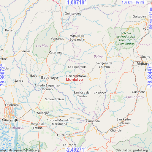
Montalvo GPS coordinates[2]
1° 47' 24.288" South, 79° 17' 15.324" West
| Map corner | latitude | longitude |
|---|---|---|
| Upper-left | -1.08718°, | -79.99072° |
| Center: | -1.79008°, | -79.28759° |
| Lower-right: | -2.49271°, | -78.58447° |
| Map W x H: | 156.3×156.3 km | = 97.1×97.1mi |
| max Lat: | 1.35251° ⇑58.7% North |
| Montalvo: | -1.79008° |
| min Lat: | ⇓41.3% South -4.38181° |
| min Long | Montalvo | max Long |
| -90.96654° | -79.28759° | -76.89528° |
| W 53.7%⇐ | ⇒46.3% E |
Elevation
Elevation of Montalvo is 65 m = 213 ft, and this is 880.1 m = 2887 ft below average elevation for this country.
| Max E: |
3131 m = 10272 ft | 57.9% |
| Avg. | 945.1 m = 3101 ft | |
| Montalvo | 65 m = 213 ft | |
Min E: |
1 m = 3 ft | 42.1% |
See also: Ecuador elevation on elevation.city.
Geographical zone
Montalvo is located in South Torrid zone (between Equator and Tropic of Capricorn). Distance of Equator is 199 km =123.7 mi to North.| Distance of | km | miles | from Montalvo |
|---|---|---|---|
| Equator | 199 | 123.7 | to North |
| Tropic Capricorn | 2406.9 | 1495.6 | to South |
| Antarctic Circle | 7202.1 | 4475.2 | to South |
| South Pole | 9808 | 6094.4 | to South |


Nearby cities:
15 places around Montalvo: (largest is in red/bold)
• Alausí
67.1 km =41.7 mi,  133°
133°
• Alfredo Baquerizo Moreno
29.1 km =18.1 mi,  241°
241°
• Babahoyo
27.5 km =17.1 mi,  267°
267°
• Catarama
30.6 km =19 mi,  321°
321°
• Coronel Marcelino Maridueña
49.3 km =30.6 mi,  199°
199°
• Guaranda
38.7 km =24 mi,  55°
55°
• Milagro
51.2 km =31.8 mi,  221°
221°
• Naranjito
46.3 km =28.8 mi,  205°
205°
• Palenque
65.2 km =40.5 mi,  306°
306°
• Palestina
50.1 km =31.1 mi,  250°
250°
• Samborondón
52.2 km =32.4 mi, 248°
• San Miguel
28.6 km =17.8 mi,  71°
71°
• Ventanas
43.2 km =26.8 mi,  333°
333°
• Vinces
57.8 km =35.9 mi,  296°
296°
• Yaguachi Nuevo
56.7 km =35.2 mi,  232°
232°
Sources, notices
• [Note1] Compared only with cities in Ecuador existing in our database
• [Src1] Map data: © OpenStreetMap contributors (CC-BY-SA)
• [Src2] Other city data from geonames.org with taken over terms of usage.
• [Src3] Geographical zone / Annual Mean Temperature by Robert A. Rohde @ Wikipedia
