Guaranda geodata
Guaranda (Bolívar) is a seat of a first-order administrative division; located in Ecuador in America/Guayaquil (GMT-5) time zone. With population of 22,199 people, there are 49 cities with bigger population in this country. Compared to other cities in Ecuador, 54.5% of cities are located further ↑North; 58.7% of cities are located further ←West and 87.6% of cities have lower elevation than Guaranda. Note1


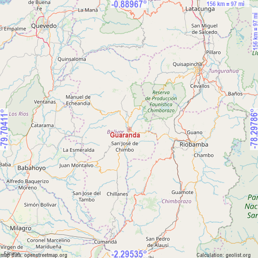
Guaranda GPS coordinates[2]
1° 35' 33.468" South, 79° 0' 3.528" West
| Map corner | latitude | longitude |
|---|---|---|
| Upper-left | -0.88967°, | -79.70411° |
| Center: | -1.59263°, | -79.00098° |
| Lower-right: | -2.29535°, | -78.29786° |
| Map W x H: | 156.3×156.3 km | = 97.1×97.1mi |
| max Lat: | 1.35251° ⇑54.5% North |
| Guaranda: | -1.59263° |
| min Lat: | ⇓45.5% South -4.38181° |
| min Long | Guaranda | max Long |
| -90.96654° | -79.00098° | -76.89528° |
| W 58.7%⇐ | ⇒41.3% E |
Elevation
Elevation of Guaranda is 2680 m = 8793 ft, and this is 1734.9 m = 5692 ft above average elevation for this country.
| Max E: |
3131 m = 10272 ft | 12.4% |
| Guaranda | 2680 m 8793 ft | |
| Avg. | 945.1 m = 3101 ft | |
Min E: |
1 m = 3 ft | 87.6% |
See also: Ecuador elevation on elevation.city.
Geographical zone
Guaranda is located in South Torrid zone (between Equator and Tropic of Capricorn). Distance of Equator is 177.1 km =110 mi to North.| Distance of | km | miles | from Guaranda |
|---|---|---|---|
| Equator | 177.1 | 110 | to North |
| Tropic Capricorn | 2428.8 | 1509.2 | to South |
| Antarctic Circle | 7224.1 | 4488.8 | to South |
| South Pole | 9830 | 6108.1 | to South |


Nearby cities:
15 places around Guaranda: (largest is in red/bold)
• Alausí
70 km =43.5 mi,  165°
165°
• Alfredo Baquerizo Moreno
67.7 km =42.1 mi,  237°
237°
• Ambato
57.3 km =35.6 mi,  48°
48°
• Babahoyo
63.7 km =39.6 mi,  248°
248°
• Baños
67.8 km =42.1 mi,  71°
71°
• Catarama
51.1 km =31.8 mi,  272°
272°
• Guano
41.2 km =25.6 mi,  92°
92°
• Montalvo
38.7 km =24 mi, 235°
• Pelileo
58.7 km =36.5 mi,  60°
60°
• Píllaro
68.7 km =42.7 mi, 47°
• Quero
49.6 km =30.8 mi, 61°
• Riobamba
40.3 km =25 mi,  102°
102°
• San Miguel
13.7 km =8.5 mi,  199°
199°
• San Miguel de Salcedo
76 km =47.2 mi,  36°
36°
• Ventanas
53.7 km =33.4 mi,  288°
288°
Sources, notices
• [Note1] Compared only with cities in Ecuador existing in our database
• [Src1] Map data: © OpenStreetMap contributors (CC-BY-SA)
• [Src2] Other city data from geonames.org with taken over terms of usage.
• [Src3] Geographical zone / Annual Mean Temperature by Robert A. Rohde @ Wikipedia
