Catarama geodata
Catarama (Los Ríos) is a populated place; located in Ecuador in America/Guayaquil (GMT-5) time zone. With population of 9,723 people, there are 84 cities with bigger population in this country. Compared to other cities in Ecuador, 53.7% of cities are located further ↑North; 50.4% of cities are located further →East and 77.7% of cities have higher elevation than Catarama. Note1


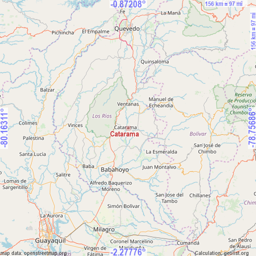
Catarama GPS coordinates[2]
1° 34' 30.144" South, 79° 27' 35.928" West
| Map corner | latitude | longitude |
|---|---|---|
| Upper-left | -0.87208°, | -80.16311° |
| Center: | -1.57504°, | -79.45998° |
| Lower-right: | -2.27776°, | -78.75686° |
| Map W x H: | 156.3×156.3 km | = 97.1×97.1mi |
| max Lat: | 1.35251° ⇑53.7% North |
| Catarama: | -1.57504° |
| min Lat: | ⇓46.3% South -4.38181° |
| min Long | Catarama | max Long |
| -90.96654° | -79.45998° | -76.89528° |
| W 49.6%⇐ | ⇒50.4% E |
Elevation
Elevation of Catarama is 17 m = 56 ft, and this is 928.1 m = 3045 ft below average elevation for this country.
| Max E: |
3131 m = 10272 ft | 77.7% |
| Avg. | 945.1 m = 3101 ft | |
| Catarama | 17 m = 56 ft | |
Min E: |
1 m = 3 ft | 22.3% |
See also: Ecuador elevation on elevation.city.
Geographical zone
Catarama is located in South Torrid zone (between Equator and Tropic of Capricorn). Distance of Equator is 175.1 km =108.8 mi to North.| Distance of | km | miles | from Catarama |
|---|---|---|---|
| Equator | 175.1 | 108.8 | to North |
| Tropic Capricorn | 2430.8 | 1510.4 | to South |
| Antarctic Circle | 7226 | 4490 | to South |
| South Pole | 9831.9 | 6109.3 | to South |


Nearby cities:
15 places around Catarama: (largest is in red/bold)
• Alfredo Baquerizo Moreno
38.5 km =23.9 mi,  189°
189°
• Babahoyo
26.6 km =16.5 mi,  198°
198°
• Balzar
54.7 km =34 mi,  295°
295°
• Colimes
61.4 km =38.2 mi,  273°
273°
• Guaranda
51.1 km =31.8 mi,  92°
92°
• Montalvo
30.6 km =19 mi,  141°
141°
• Palenque
36.3 km =22.6 mi,  294°
294°
• Palestina
49.2 km =30.6 mi,  215°
215°
• Quevedo
60.8 km =37.8 mi,  359°
359°
• Samborondón
52.1 km =32.4 mi,  214°
214°
• San Miguel
48.7 km =30.3 mi,  107°
107°
• Velasco Ibarra
62.3 km =38.7 mi,  341°
341°
• Ventanas
14.8 km =9.2 mi,  0°
0°
• Vinces
32.5 km =20.2 mi, 273°
• Yaguachi Nuevo
63.6 km =39.5 mi, 204°
Sources, notices
• [Note1] Compared only with cities in Ecuador existing in our database
• [Src1] Map data: © OpenStreetMap contributors (CC-BY-SA)
• [Src2] Other city data from geonames.org with taken over terms of usage.
• [Src3] Geographical zone / Annual Mean Temperature by Robert A. Rohde @ Wikipedia
