Ventanas geodata
Ventanas (Los Ríos) is a populated place; located in Ecuador in America/Guayaquil (GMT-5) time zone. With population of 46,708 people, there are 22 cities with bigger population in this country. Compared to other cities in Ecuador, 50.4% of cities are located further ↓South; 50.4% of cities are located further ←West and 72.7% of cities have higher elevation than Ventanas. Note1


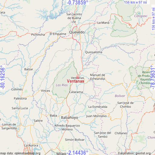
Ventanas GPS coordinates[2]
1° 26' 29.688" South, 79° 27' 33.948" West
| Map corner | latitude | longitude |
|---|---|---|
| Upper-left | -0.73859°, | -80.16256° |
| Center: | -1.44158°, | -79.45943° |
| Lower-right: | -2.14436°, | -78.75631° |
| Map W x H: | 156.3×156.3 km | = 97.1×97.1mi |
| max Lat: | 1.35251° ⇑49.6% North |
| Ventanas: | -1.44158° |
| min Lat: | ⇓50.4% South -4.38181° |
| min Long | Ventanas | max Long |
| -90.96654° | -79.45943° | -76.89528° |
| W 50.4%⇐ | ⇒49.6% E |
Elevation
Elevation of Ventanas is 24 m = 79 ft, and this is 921.1 m = 3022 ft below average elevation for this country.
| Max E: |
3131 m = 10272 ft | 72.7% |
| Avg. | 945.1 m = 3101 ft | |
| Ventanas | 24 m = 79 ft | |
Min E: |
1 m = 3 ft | 27.3% |
See also: Ventanas elevation on elevation.city.
Geographical zone
Ventanas is located in South Torrid zone (between Equator and Tropic of Capricorn). Distance of Equator is 160.3 km =99.6 mi to North.| Distance of | km | miles | from Ventanas |
|---|---|---|---|
| Equator | 160.3 | 99.6 | to North |
| Tropic Capricorn | 2445.6 | 1519.6 | to South |
| Antarctic Circle | 7240.9 | 4499.3 | to South |
| South Pole | 9846.8 | 6118.5 | to South |


Nearby cities:
15 places around Ventanas: (largest is in red/bold)
• Alfredo Baquerizo Moreno
53.2 km =33.1 mi,  186°
186°
• Babahoyo
41 km =25.5 mi, 191°
• Balzar
50.2 km =31.2 mi,  279°
279°
• Catarama
14.8 km =9.2 mi,  180°
180°
• Colimes
62.5 km =38.8 mi,  259°
259°
• Guaranda
53.7 km =33.4 mi,  108°
108°
• La Maná
61.5 km =38.2 mi,  25°
25°
• Montalvo
43.2 km =26.8 mi,  153°
153°
• Palenque
33 km =20.5 mi,  270°
270°
• Palestina
61.9 km =38.5 mi,  207°
207°
• Quevedo
45.9 km =28.5 mi,  359°
359°
• Samborondón
65 km =40.4 mi, 206°
• San Miguel
55 km =34.2 mi,  122°
122°
• Velasco Ibarra
48.5 km =30.1 mi,  335°
335°
• Vinces
34.9 km =21.7 mi,  248°
248°
Sources, notices
• [Note1] Compared only with cities in Ecuador existing in our database
• [Src1] Map data: © OpenStreetMap contributors (CC-BY-SA)
• [Src2] Other city data from geonames.org with taken over terms of usage.
• [Src3] Geographical zone / Annual Mean Temperature by Robert A. Rohde @ Wikipedia
