San Miguel geodata
San Miguel (Bolívar) is a populated place; located in Ecuador in America/Guayaquil (GMT-5) time zone. With population of 12,575 people, there are 74 cities with bigger population in this country. Compared to other cities in Ecuador, 57.9% of cities are located further ↑North; 57% of cities are located further ←West and 79.3% of cities have lower elevation than San Miguel. Note1


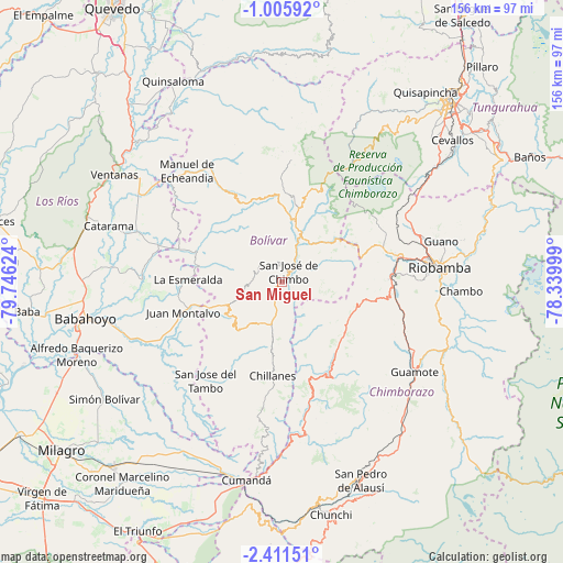
San Miguel GPS coordinates[2]
1° 42' 31.824" South, 79° 2' 35.196" West
| Map corner | latitude | longitude |
|---|---|---|
| Upper-left | -1.00592°, | -79.74624° |
| Center: | -1.70884°, | -79.04311° |
| Lower-right: | -2.41151°, | -78.33999° |
| Map W x H: | 156.3×156.3 km | = 97.1×97.1mi |
| max Lat: | 1.35251° ⇑57.9% North |
| San Miguel: | -1.70884° |
| min Lat: | ⇓42.1% South -4.38181° |
| min Long | San Miguel | max Long |
| -90.96654° | -79.04311° | -76.89528° |
| W 57%⇐ | ⇒43% E |
Elevation
Elevation of San Miguel is 2444 m = 8018 ft, and this is 1498.9 m = 4918 ft above average elevation for this country.
| Max E: |
3131 m = 10272 ft | 20.7% |
| San Miguel | 2444 m 8018 ft | |
| Avg. | 945.1 m = 3101 ft | |
Min E: |
1 m = 3 ft | 79.3% |
See also: Ecuador elevation on elevation.city.
Geographical zone
San Miguel is located in South Torrid zone (between Equator and Tropic of Capricorn). Distance of Equator is 190 km =118.1 mi to North.| Distance of | km | miles | from San Miguel |
|---|---|---|---|
| Equator | 190 | 118.1 | to North |
| Tropic Capricorn | 2415.9 | 1501.2 | to South |
| Antarctic Circle | 7211.2 | 4480.8 | to South |
| South Pole | 9817.1 | 6100.1 | to South |


Nearby cities:
15 places around San Miguel: (largest is in red/bold)
• Alausí
59.1 km =36.7 mi,  158°
158°
• Alfredo Baquerizo Moreno
57.5 km =35.7 mi,  246°
246°
• Ambato
69.7 km =43.3 mi,  42°
42°
• Babahoyo
55.6 km =34.5 mi,  259°
259°
• Baños
77.2 km =48 mi,  63°
63°
• Catarama
48.7 km =30.3 mi,  287°
287°
• Coronel Marcelino Maridueña
70.5 km =43.8 mi,  217°
217°
• Guano
47.2 km =29.3 mi,  76°
76°
• Guaranda
13.7 km =8.5 mi,  19°
19°
• Montalvo
28.6 km =17.8 mi, 251°
• Naranjito
69.2 km =43 mi, 222°
• Pelileo
69.7 km =43.3 mi,  52°
52°
• Quero
60.5 km =37.6 mi, 53°
• Riobamba
44.2 km =27.5 mi, 84°
• Ventanas
55 km =34.2 mi,  302°
302°
Sources, notices
• [Note1] Compared only with cities in Ecuador existing in our database
• [Src1] Map data: © OpenStreetMap contributors (CC-BY-SA)
• [Src2] Other city data from geonames.org with taken over terms of usage.
• [Src3] Geographical zone / Annual Mean Temperature by Robert A. Rohde @ Wikipedia
