Macas geodata
Macas (Morona-Santiago) is a seat of a first-order administrative division; located in Ecuador in America/Guayaquil (GMT-5) time zone. With population of 23,687 people, there are 47 cities with bigger population in this country. Compared to other cities in Ecuador, 75.2% of cities are located further ↑North; 87.6% of cities are located further ←West and 64.5% of cities have lower elevation than Macas. Note1


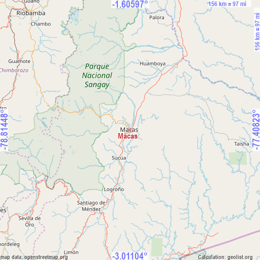
Macas GPS coordinates[2]
2° 18' 31.248" South, 78° 6' 40.86" West
| Map corner | latitude | longitude |
|---|---|---|
| Upper-left | -1.60597°, | -78.81448° |
| Center: | -2.30868°, | -78.11135° |
| Lower-right: | -3.01104°, | -77.40823° |
| Map W x H: | 156.2×156.2 km | = 97.1×97.1mi |
| max Lat: | 1.35251° ⇑75.2% North |
| Macas: | -2.30868° |
| min Lat: | ⇓24.8% South -4.38181° |
| min Long | Macas | max Long |
| -90.96654° | -78.11135° | -76.89528° |
| W 87.6%⇐ | ⇒12.4% E |
Elevation
Elevation of Macas is 914 m = 2999 ft, and this is 31.1 m = 102 ft below average elevation for this country.
| Max E: |
3131 m = 10272 ft | 35.5% |
| Avg. | 945.1 m = 3101 ft | |
| Macas | 914 m = 2999 ft | |
Min E: |
1 m = 3 ft | 64.5% |
See also: Ecuador elevation on elevation.city.
Geographical zone
Macas is located in South Torrid zone (between Equator and Tropic of Capricorn). Distance of Equator is 256.7 km =159.5 mi to North.| Distance of | km | miles | from Macas |
|---|---|---|---|
| Equator | 256.7 | 159.5 | to North |
| Tropic Capricorn | 2349.2 | 1459.7 | to South |
| Antarctic Circle | 7144.5 | 4439.4 | to South |
| South Pole | 9750.4 | 6058.6 | to South |


Nearby cities:
15 places around Macas: (largest is in red/bold)
• Alausí
82.6 km =51.3 mi,  278°
278°
• Azogues
94.9 km =59 mi,  239°
239°
• Baños
107.1 km =66.5 mi,  341°
341°
• Cañar
96.2 km =59.8 mi,  253°
253°
• Gualaceo
98.5 km =61.2 mi,  228°
228°
• Guano
97 km =60.3 mi,  323°
323°
• La Unión
95.9 km =59.6 mi, 231°
• Llacao
105.8 km =65.7 mi, 234°
• Nulti
106.3 km =66.1 mi, 230°
• Palora
69.5 km =43.2 mi,  13°
13°
• Puyo
92.5 km =57.5 mi, 7°
• Quero
117 km =72.7 mi,  331°
331°
• Riobamba
92.6 km =57.5 mi, 319°
• Sucúa
18 km =11.2 mi,  201°
201°
• Taisha
72.4 km =45 mi,  92°
92°
Sources, notices
• [Note1] Compared only with cities in Ecuador existing in our database
• [Src1] Map data: © OpenStreetMap contributors (CC-BY-SA)
• [Src2] Other city data from geonames.org with taken over terms of usage.
• [Src3] Geographical zone / Annual Mean Temperature by Robert A. Rohde @ Wikipedia
