Puyo geodata
Puyo (Pastaza) is a seat of a first-order administrative division; located in Ecuador in America/Guayaquil (GMT-5) time zone. With population of 24,881 people, there are 44 cities with bigger population in this country. Compared to other cities in Ecuador, 50.4% of cities are located further ↑North; 88.4% of cities are located further ←West and 66.1% of cities have lower elevation than Puyo. Note1


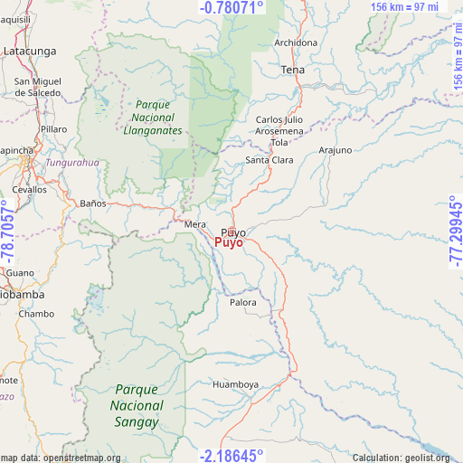
Puyo GPS coordinates[2]
1° 29' 1.284" South, 78° 0' 9.252" West
| Map corner | latitude | longitude |
|---|---|---|
| Upper-left | -0.78071°, | -78.7057° |
| Center: | -1.48369°, | -78.00257° |
| Lower-right: | -2.18645°, | -77.29945° |
| Map W x H: | 156.3×156.3 km | = 97.1×97.1mi |
| max Lat: | 1.35251° ⇑50.4% North |
| Puyo: | -1.48369° |
| min Lat: | ⇓49.6% South -4.38181° |
| min Long | Puyo | max Long |
| -90.96654° | -78.00257° | -76.89528° |
| W 88.4%⇐ | ⇒11.6% E |
Elevation
Elevation of Puyo is 925 m = 3035 ft, and this is 20.1 m = 66 ft below average elevation for this country.
| Max E: |
3131 m = 10272 ft | 33.9% |
| Avg. | 945.1 m = 3101 ft | |
| Puyo | 925 m = 3035 ft | |
Min E: |
1 m = 3 ft | 66.1% |
See also: Ecuador elevation on elevation.city.
Geographical zone
Puyo is located in South Torrid zone (between Equator and Tropic of Capricorn). Distance of Equator is 165 km =102.5 mi to North.| Distance of | km | miles | from Puyo |
|---|---|---|---|
| Equator | 165 | 102.5 | to North |
| Tropic Capricorn | 2440.9 | 1516.7 | to South |
| Antarctic Circle | 7236.2 | 4496.4 | to South |
| South Pole | 9842.1 | 6115.6 | to South |


Nearby cities:
15 places around Puyo: (largest is in red/bold)
• Ambato
73.1 km =45.4 mi,  290°
290°
• Archidona
67.4 km =41.9 mi,  18°
18°
• Baños
47.7 km =29.6 mi,  281°
281°
• Guano
71.2 km =44.2 mi,  258°
258°
• Latacunga
91.4 km =56.8 mi,  311°
311°
• Macas
92.5 km =57.5 mi,  187°
187°
• Palora
24.6 km =15.3 mi,  170°
170°
• Pelileo
62.5 km =38.8 mi, 285°
• Pujilí
96.8 km =60.1 mi, 307°
• Píllaro
69.6 km =43.2 mi,  299°
299°
• Quero
68.3 km =42.4 mi, 279°
• Riobamba
74.6 km =46.4 mi,  253°
253°
• San Miguel de Salcedo
81.5 km =50.6 mi, 306°
• Santa Clara
27.6 km =17.1 mi,  27°
27°
• Tena
58.4 km =36.3 mi, 21°
Sources, notices
• [Note1] Compared only with cities in Ecuador existing in our database
• [Src1] Map data: © OpenStreetMap contributors (CC-BY-SA)
• [Src2] Other city data from geonames.org with taken over terms of usage.
• [Src3] Geographical zone / Annual Mean Temperature by Robert A. Rohde @ Wikipedia
