Gualaceo geodata
Gualaceo (Azuay) is a populated place; located in Ecuador in America/Guayaquil (GMT-5) time zone. With population of 17,122 people, there are 57 cities with bigger population in this country. Compared to other cities in Ecuador, 83.5% of cities are located further ↑North; 67.8% of cities are located further ←West and 75.2% of cities have lower elevation than Gualaceo. Note1


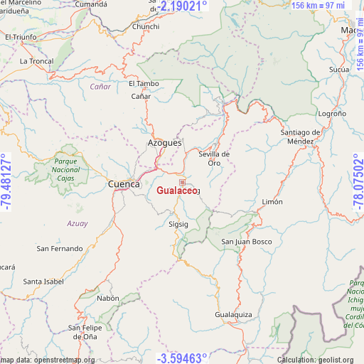
Gualaceo GPS coordinates[2]
2° 53' 33.504" South, 78° 46' 41.304" West
| Map corner | latitude | longitude |
|---|---|---|
| Upper-left | -2.19021°, | -79.48127° |
| Center: | -2.89264°, | -78.77814° |
| Lower-right: | -3.59463°, | -78.07502° |
| Map W x H: | 156.2×156.2 km | = 97.1×97.1mi |
| max Lat: | 1.35251° ⇑83.5% North |
| Gualaceo: | -2.89264° |
| min Lat: | ⇓16.5% South -4.38181° |
| min Long | Gualaceo | max Long |
| -90.96654° | -78.77814° | -76.89528° |
| W 67.8%⇐ | ⇒32.2% E |
Elevation
Elevation of Gualaceo is 2233 m = 7326 ft, and this is 1287.9 m = 4225 ft above average elevation for this country.
| Max E: |
3131 m = 10272 ft | 24.8% |
| Gualaceo | 2233 m 7326 ft | |
| Avg. | 945.1 m = 3101 ft | |
Min E: |
1 m = 3 ft | 75.2% |
See also: Ecuador elevation on elevation.city.
Geographical zone
Gualaceo is located in South Torrid zone (between Equator and Tropic of Capricorn). Distance of Equator is 321.6 km =199.8 mi to North.| Distance of | km | miles | from Gualaceo |
|---|---|---|---|
| Equator | 321.6 | 199.8 | to North |
| Tropic Capricorn | 2284.3 | 1419.4 | to South |
| Antarctic Circle | 7079.5 | 4399 | to South |
| South Pole | 9685.4 | 6018.2 | to South |


Nearby cities:
15 places around Gualaceo: (largest is in red/bold)
• Alausí
77 km =47.8 mi,  354°
354°
• Azogues
18.7 km =11.6 mi,  335°
335°
• Cañar
41 km =25.5 mi,  334°
334°
• Coronel Marcelino Maridueña
105.2 km =65.4 mi,  316°
316°
• Cuenca
25.2 km =15.7 mi,  267°
267°
• Gualaquiza
60.9 km =37.8 mi,  158°
158°
• La Troncal
81.3 km =50.5 mi,  309°
309°
• La Unión
4.8 km =3 mi, 353°
• Llacao
12 km =7.5 mi,  283°
283°
• Macas
98.5 km =61.2 mi,  48°
48°
• Naranjal
96.4 km =59.9 mi, 284°
• Naranjito
111.1 km =69 mi, 316°
• Nulti
8.4 km =5.2 mi,  251°
251°
• Sucúa
82.9 km =51.5 mi, 54°
• Yantzaza
104.5 km =64.9 mi,  178°
178°
Sources, notices
• [Note1] Compared only with cities in Ecuador existing in our database
• [Src1] Map data: © OpenStreetMap contributors (CC-BY-SA)
• [Src2] Other city data from geonames.org with taken over terms of usage.
• [Src3] Geographical zone / Annual Mean Temperature by Robert A. Rohde @ Wikipedia
