Nulti geodata
Nulti (Azuay) is a populated place; located in Ecuador in America/Guayaquil (GMT-5) time zone. With population of 4,589 people, there are 106 cities with bigger population in this country. Compared to other cities in Ecuador, 86% of cities are located further ↑North; 63.6% of cities are located further ←West and 99.2% of cities have lower elevation than Nulti. Note1


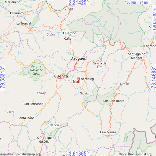
Nulti GPS coordinates[2]
2° 55' 0.012" South, 78° 51' 0" West
| Map corner | latitude | longitude |
|---|---|---|
| Upper-left | -2.21425°, | -79.55313° |
| Center: | -2.91667°, | -78.85° |
| Lower-right: | -3.61865°, | -78.14688° |
| Map W x H: | 156.2×156.2 km | = 97.1×97.1mi |
| max Lat: | 1.35251° ⇑86% North |
| Nulti: | -2.91667° |
| min Lat: | ⇓14% South -4.38181° |
| min Long | Nulti | max Long |
| -90.96654° | -78.85° | -76.89528° |
| W 63.6%⇐ | ⇒36.4% E |
Elevation
Elevation of Nulti is 3087 m = 10128 ft, and this is 2141.9 m = 7027 ft above average elevation for this country.
| Max E: |
3131 m = 10272 ft | 0.8% |
| Nulti | 3087 m 10128 ft | |
| Avg. | 945.1 m = 3101 ft | |
Min E: |
1 m = 3 ft | 99.2% |
See also: Ecuador elevation on elevation.city.
Geographical zone
Nulti is located in South Torrid zone (between Equator and Tropic of Capricorn). Distance of Equator is 324.3 km =201.5 mi to North.| Distance of | km | miles | from Nulti |
|---|---|---|---|
| Equator | 324.3 | 201.5 | to North |
| Tropic Capricorn | 2281.6 | 1417.7 | to South |
| Antarctic Circle | 7076.9 | 4397.4 | to South |
| South Pole | 9682.8 | 6016.6 | to South |


Nearby cities:
15 places around Nulti: (largest is in red/bold)
• Alausí
79.3 km =49.3 mi,  0°
0°
• Azogues
19.7 km =12.2 mi, 0°
• Baláo
107.1 km =66.5 mi,  270°
270°
• Cañar
40.8 km =25.4 mi,  345°
345°
• Coronel Marcelino Maridueña
101.8 km =63.3 mi,  320°
320°
• Cuenca
17.3 km =10.7 mi,  275°
275°
• Gualaceo
8.4 km =5.2 mi,  71°
71°
• Gualaquiza
61.8 km =38.4 mi,  151°
151°
• La Troncal
77.2 km =48 mi, 315°
• La Unión
10.5 km =6.5 mi,  44°
44°
• Llacao
6.7 km =4.2 mi,  326°
326°
• Macas
106.3 km =66.1 mi,  50°
50°
• Naranjal
89.5 km =55.6 mi,  287°
287°
• Sucúa
90.9 km =56.5 mi,  55°
55°
• Yantzaza
102.3 km =63.6 mi,  174°
174°
Sources, notices
• [Note1] Compared only with cities in Ecuador existing in our database
• [Src1] Map data: © OpenStreetMap contributors (CC-BY-SA)
• [Src2] Other city data from geonames.org with taken over terms of usage.
• [Src3] Geographical zone / Annual Mean Temperature by Robert A. Rohde @ Wikipedia
