Palora geodata
Palora (Morona-Santiago) is a populated place; located in Ecuador in America/Guayaquil (GMT-5) time zone. With population of 6,472 people, there are 101 cities with bigger population in this country. Compared to other cities in Ecuador, 57% of cities are located further ↑North; 89.3% of cities are located further ←West and 63.6% of cities have lower elevation than Palora. Note1
Administrative division(s):
- Level 1: Morona-Santiago
- Level 2: Cantón Palora
- Level 3: Palora (Metzera)


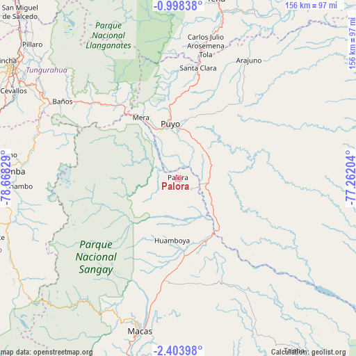
Palora GPS coordinates[2]
1° 42' 4.716" South, 77° 57' 54.576" West
| Map corner | latitude | longitude |
|---|---|---|
| Upper-left | -0.99838°, | -78.66829° |
| Center: | -1.70131°, | -77.96516° |
| Lower-right: | -2.40398°, | -77.26204° |
| Map W x H: | 156.3×156.3 km | = 97.1×97.1mi |
| max Lat: | 1.35251° ⇑57% North |
| Palora: | -1.70131° |
| min Lat: | ⇓43% South -4.38181° |
| min Long | Palora | max Long |
| -90.96654° | -77.96516° | -76.89528° |
| W 89.3%⇐ | ⇒10.7% E |
Elevation
Elevation of Palora is 880 m = 2887 ft, and this is 65.1 m = 214 ft below average elevation for this country.
| Max E: |
3131 m = 10272 ft | 36.4% |
| Avg. | 945.1 m = 3101 ft | |
| Palora | 880 m = 2887 ft | |
Min E: |
1 m = 3 ft | 63.6% |
See also: Ecuador elevation on elevation.city.
Geographical zone
Palora is located in South Torrid zone (between Equator and Tropic of Capricorn). Distance of Equator is 189.2 km =117.6 mi to North.| Distance of | km | miles | from Palora |
|---|---|---|---|
| Equator | 189.2 | 117.6 | to North |
| Tropic Capricorn | 2416.8 | 1501.7 | to South |
| Antarctic Circle | 7212 | 4481.3 | to South |
| South Pole | 9817.9 | 6100.6 | to South |


Nearby cities:
15 places around Palora: (largest is in red/bold)
• Ambato
88.2 km =54.8 mi,  304°
304°
• Archidona
89.8 km =55.8 mi,  11°
11°
• Baños
61.1 km =38 mi, 303°
• Guano
74.7 km =46.4 mi,  277°
277°
• Macas
69.5 km =43.2 mi,  193°
193°
• Pelileo
76.4 km =47.5 mi, 302°
• Puyo
24.6 km =15.3 mi,  350°
350°
• Píllaro
87.3 km =54.2 mi,  312°
312°
• Quero
79.8 km =49.6 mi, 296°
• Riobamba
75.9 km =47.2 mi,  272°
272°
• San Miguel de Salcedo
100.8 km =62.6 mi,  316°
316°
• Santa Clara
49.4 km =30.7 mi, 10°
• Sucúa
87.3 km =54.2 mi,  195°
195°
• Taisha
90.5 km =56.2 mi,  141°
141°
• Tena
80.5 km =50 mi, 12°
Sources, notices
• [Note1] Compared only with cities in Ecuador existing in our database
• [Src1] Map data: © OpenStreetMap contributors (CC-BY-SA)
• [Src2] Other city data from geonames.org with taken over terms of usage.
• [Src3] Geographical zone / Annual Mean Temperature by Robert A. Rohde @ Wikipedia
