San Lorenzo de Esmeraldas geodata
San Lorenzo de Esmeraldas (Esmeraldas) is a populated place; located in Ecuador in America/Guayaquil (GMT-5) time zone. With population of 20,209 people, there are 51 cities with bigger population in this country. Compared to other cities in Ecuador, 99.2% of cities are located further ↓South; 66.1% of cities are located further ←West and 83.5% of cities have higher elevation than San Lorenzo de Esmeraldas. Note1
Current local time in San Lorenzo de Esmeraldas:
11:01 PM, FridayDifference from your time zone: hours


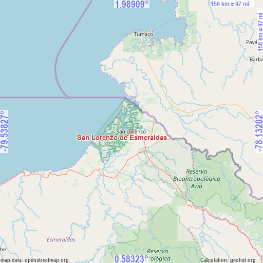
San Lorenzo de Esmeraldas GPS coordinates[2]
1° 17' 10.536" North, 78° 50' 6.504" West
| Map corner | latitude | longitude |
|---|---|---|
| Upper-left | 1.98909°, | -79.53827° |
| Center: | 1.28626°, | -78.83514° |
| Lower-right: | 0.58323°, | -78.13202° |
| Map W x H: | 156.3×156.3 km | = 97.1×97.1mi |
| max Lat: | 1.35251° ⇑0.8% North |
| San Lorenzo de Esmeraldas: | 1.28626° |
| min Lat: | ⇓99.2% South -4.38181° |
| min Long | San Lorenzo de | max Long |
| -90.96654° | -78.83514° | -76.89528° |
| W 66.1%⇐ | ⇒33.9% E |
Elevation
Elevation of San Lorenzo de Esmeraldas is 14 m = 46 ft, and this is 931.1 m = 3055 ft below average elevation for this country.
| Max E: |
3131 m = 10272 ft | 83.5% |
| Avg. | 945.1 m = 3101 ft | |
| San Lorenzo de Esmeraldas | 14 m = 46 ft | |
Min E: |
1 m = 3 ft | 16.5% |
See also: Ecuador elevation on elevation.city.
Geographical zone
San Lorenzo de Esmeraldas is located in North Torrid zone (between Equator and Tropic of Cancer). Distance of Equator is 143 km =88.9 mi to South.| Distance of | km | miles | from San Lorenzo de Esmeraldas |
|---|---|---|---|
| North Pole | 9864 | 6129.2 | to North |
| Arctic Circle | 7258.2 | 4510 | to North |
| Tropic Cancer | 2462.9 | 1530.4 | to North |
| Equator | 143 | 88.9 | to South |


Nearby cities:
15 places around San Lorenzo de Esmeraldas: (largest is in red/bold)
• Atuntaqui
126.6 km =78.7 mi,  146°
146°
• Cayambe
158.3 km =98.4 mi, 151°
• Cotacachi
126.6 km =78.7 mi, 149°
• Cube
119.9 km =74.5 mi,  228°
228°
• El Ángel
123.9 km =77 mi,  126°
126°
• Esmeraldas
98 km =60.9 mi,  248°
248°
• Ibarra
130.7 km =81.2 mi,  142°
142°
• Muisne
151.5 km =94.1 mi,  240°
240°
• Otavalo
133.1 km =82.7 mi, 151°
• Pampanal de Bolívar
9.8 km =6.1 mi,  318°
318°
• Pimampiro
140.7 km =87.4 mi, 135°
• Rosa Zarate
128.1 km =79.6 mi,  213°
213°
• San Gabriel
135.7 km =84.3 mi,  124°
124°
• Tulcán
135 km =83.9 mi,  112°
112°
• Valdez
17 km =10.6 mi,  255°
255°
Sources, notices
• [Note1] Compared only with cities in Ecuador existing in our database
• [Src1] Map data: © OpenStreetMap contributors (CC-BY-SA)
• [Src2] Other city data from geonames.org with taken over terms of usage.
• [Src3] Geographical zone / Annual Mean Temperature by Robert A. Rohde @ Wikipedia
