Pampanal de Bolívar geodata
Pampanal de Bolívar (Esmeraldas) is a populated place; located in Ecuador in America/Guayaquil (GMT-5) time zone. With population of 1,118 people, there are 113 cities with bigger population in this country. Compared to other cities in Ecuador, 100% of cities are located further ↓South; 62% of cities are located further ←West and 95.9% of cities have higher elevation than Pampanal de Bolívar. Note1


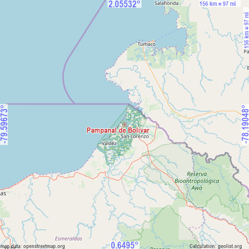
Pampanal de Bolívar GPS coordinates[2]
1° 21' 9.036" North, 78° 53' 36.96" West
| Map corner | latitude | longitude |
|---|---|---|
| Upper-left | 2.05532°, | -79.59673° |
| Center: | 1.35251°, | -78.8936° |
| Lower-right: | 0.6495°, | -78.19048° |
| Map W x H: | 156.3×156.3 km | = 97.1×97.1mi |
| max Lat: | 1.35251° ⇑0% North |
| Pampanal de Bolívar: | 1.35251° |
| min Lat: | ⇓100% South -4.38181° |
| min Long | Pampanal de Bol | max Long |
| -90.96654° | -78.8936° | -76.89528° |
| W 62%⇐ | ⇒38% E |
Elevation
Elevation of Pampanal de Bolívar is 7 m = 23 ft, and this is 938.1 m = 3078 ft below average elevation for this country.
| Max E: |
3131 m = 10272 ft | 95.9% |
| Avg. | 945.1 m = 3101 ft | |
| Pampanal de Bolívar | 7 m = 23 ft | |
Min E: |
1 m = 3 ft | 4.1% |
See also: Ecuador elevation on elevation.city.
Geographical zone
Pampanal de Bolívar is located in North Torrid zone (between Equator and Tropic of Cancer). Distance of Equator is 150.4 km =93.5 mi to South.| Distance of | km | miles | from Pampanal de Bolívar |
|---|---|---|---|
| North Pole | 9856.7 | 6124.7 | to North |
| Arctic Circle | 7250.8 | 4505.4 | to North |
| Tropic Cancer | 2455.5 | 1525.8 | to North |
| Equator | 150.4 | 93.5 | to South |


Nearby cities:
15 places around Pampanal de Bolívar: (largest is in red/bold)
• Atuntaqui
136.3 km =84.7 mi,  146°
146°
• Cayambe
167.9 km =104.3 mi, 150°
• Cotacachi
136.2 km =84.6 mi, 149°
• Cube
120.3 km =74.8 mi,  223°
223°
• El Ángel
133.5 km =83 mi,  127°
127°
• Esmeraldas
95.2 km =59.2 mi,  242°
242°
• Ibarra
140.5 km =87.3 mi,  142°
142°
• Muisne
149.8 km =93.1 mi, 236°
• Otavalo
142.7 km =88.7 mi, 150°
• Pimampiro
150.5 km =93.5 mi, 135°
• Rosa Zarate
130.9 km =81.3 mi,  209°
209°
• San Gabriel
145.2 km =90.2 mi, 125°
• San Lorenzo de Esmeraldas
9.8 km =6.1 mi, 138°
• Tulcán
143.9 km =89.4 mi,  114°
114°
• Valdez
15.2 km =9.4 mi, 220°
Sources, notices
• [Note1] Compared only with cities in Ecuador existing in our database
• [Src1] Map data: © OpenStreetMap contributors (CC-BY-SA)
• [Src2] Other city data from geonames.org with taken over terms of usage.
• [Src3] Geographical zone / Annual Mean Temperature by Robert A. Rohde @ Wikipedia
