Quevedo geodata
Quevedo (Los Ríos) is a populated place; located in Ecuador in America/Guayaquil (GMT-5) time zone. With population of 119,436 people, there are 14 cities with bigger population in this country. Compared to other cities in Ecuador, 63.6% of cities are located further ↓South; 51.2% of cities are located further →East and 61.2% of cities have higher elevation than Quevedo. Note1


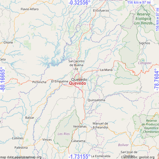
Quevedo GPS coordinates[2]
1° 1' 43.068" South, 79° 27' 48.672" West
| Map corner | latitude | longitude |
|---|---|---|
| Upper-left | -0.32556°, | -80.16665° |
| Center: | -1.02863°, | -79.46352° |
| Lower-right: | -1.73155°, | -78.7604° |
| Map W x H: | 156.3×156.3 km | = 97.1×97.1mi |
| max Lat: | 1.35251° ⇑36.4% North |
| Quevedo: | -1.02863° |
| min Lat: | ⇓63.6% South -4.38181° |
| min Long | Quevedo | max Long |
| -90.96654° | -79.46352° | -76.89528° |
| W 48.8%⇐ | ⇒51.2% E |
Elevation
Elevation of Quevedo is 51 m = 167 ft, and this is 894.1 m = 2933 ft below average elevation for this country.
| Max E: |
3131 m = 10272 ft | 61.2% |
| Avg. | 945.1 m = 3101 ft | |
| Quevedo | 51 m = 167 ft | |
Min E: |
1 m = 3 ft | 38.8% |
See also: Quevedo elevation on elevation.city.
Geographical zone
Quevedo is located in South Torrid zone (between Equator and Tropic of Capricorn). Distance of Equator is 114.4 km =71.1 mi to North.| Distance of | km | miles | from Quevedo |
|---|---|---|---|
| Equator | 114.4 | 71.1 | to North |
| Tropic Capricorn | 2491.5 | 1548.1 | to South |
| Antarctic Circle | 7286.8 | 4527.8 | to South |
| South Pole | 9892.7 | 6147 | to South |


Nearby cities:
15 places around Quevedo: (largest is in red/bold)
• Babahoyo
86.4 km =53.7 mi,  185°
185°
• Balzar
61.7 km =38.3 mi,  232°
232°
• Calceta
80.5 km =50 mi,  284°
284°
• Catarama
60.8 km =37.8 mi,  179°
179°
• Chone
79.1 km =49.2 mi,  297°
297°
• Colimes
83.8 km =52.1 mi, 226°
• Guaranda
81.1 km =50.4 mi,  140°
140°
• Junín
83.3 km =51.8 mi, 277°
• La Maná
28.2 km =17.5 mi,  69°
69°
• Palenque
56 km =34.8 mi,  215°
215°
• Pujilí
85.7 km =53.3 mi,  84°
84°
• Velasco Ibarra
19.5 km =12.1 mi,  265°
265°
• Ventanas
45.9 km =28.5 mi, 179°
• Vinces
66.8 km =41.5 mi,  208°
208°
• Wilfrido Loor Moreira
78.3 km =48.7 mi,  343°
343°
Sources, notices
• [Note1] Compared only with cities in Ecuador existing in our database
• [Src1] Map data: © OpenStreetMap contributors (CC-BY-SA)
• [Src2] Other city data from geonames.org with taken over terms of usage.
• [Src3] Geographical zone / Annual Mean Temperature by Robert A. Rohde @ Wikipedia
