Al Bawīţī geodata
Al Bawīţī (Giza) is a populated place; located in Egypt in Africa/Cairo (GMT+2) time zone. With population of 20,000 people, there are 120 cities with bigger population in this country. Compared to other cities in Egypt, 71% of cities are located further ↑North; 97.8% of cities are located further →East and 97.8% of cities have lower elevation than Al Bawīţī. Note1


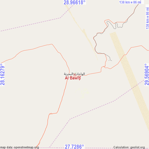
Al Bawīţī GPS coordinates[2]
28° 20' 57.084" North, 28° 51' 57.276" East
| Map corner | latitude | longitude |
|---|---|---|
| Upper-left | 28.96618°, | 28.16279° |
| Center: | 28.34919°, | 28.86591° |
| Lower-right: | 27.7286°, | 29.56904° |
| Map W x H: | 137.6×137.6 km | = 85.5×85.5mi |
| max Lat: | 31.5084° ⇑71% North |
| Al Bawīţī: | 28.34919° |
| min Lat: | ⇓29% South 22.3457° |
| min Long | Al Bawīţī | max Long |
| 25.51965° | 28.86591° | 34.89572° |
| W 2.2%⇐ | ⇒97.8% E |
Elevation
Elevation of Al Bawīţī is 130 m = 427 ft, and this is 86.5 m = 284 ft above average elevation for this country.
| Max E: |
1565 m = 5135 ft | 2.2% |
| Al Bawīţī | 130 m 427 ft | |
| Avg. | 43.5 m = 143 ft | |
Min E: |
-15 m = -49 ft | 97.8% |
See also: Egypt elevation on elevation.city.
Geographical zone
Al Bawīţī is located in North temperate zone (between Tropic of Cancer and the Arctic Circle). Distance of this Northern Tropic circle is 546.2 km =339.4 mi to South.| Distance of | km | miles | from Al Bawīţī |
|---|---|---|---|
| North Pole | 6854.9 | 4259.4 | to North |
| Arctic Circle | 4249 | 2640.2 | to North |
| Tropic Cancer | 546.2 | 339.4 | to South |
| Equator | 3152.1 | 1958.6 | to South |


Nearby cities:
15 places around Al Bawīţī: (largest is in red/bold)
• Abū Qurqāş
198.9 km =123.6 mi,  103°
103°
• Al Fashn
205.5 km =127.7 mi,  75°
75°
• Al Fayyūm
220.1 km =136.8 mi,  60°
60°
• Al Minyā
186.5 km =115.9 mi, 98°
• Al Qūşīyah
216.9 km =134.8 mi,  117°
117°
• Banī Mazār
189.9 km =118 mi, 84°
• Dayr Mawās
209.8 km =130.4 mi,  112°
112°
• Dayrūţ
210.1 km =130.6 mi, 114°
• Ibshawāy
209.4 km =130.1 mi, 57°
• Iţsā
211.9 km =131.7 mi, 62°
• Mallawī
205.7 km =127.8 mi, 109°
• Maţāy
187.3 km =116.4 mi,  87°
87°
• Qaşr al Farāfirah
168.6 km =104.8 mi,  211°
211°
• Samālūţ
180.5 km =112.2 mi, 91°
• Sumusţā as Sulţānī
203.6 km =126.5 mi,  71°
71°
Sources, notices
• [Note1] Compared only with cities in Egypt existing in our database
• [Src1] Map data: © OpenStreetMap contributors (CC-BY-SA)
• [Src2] Other city data from geonames.org with taken over terms of usage.
• [Src3] Geographical zone / Annual Mean Temperature by Robert A. Rohde @ Wikipedia
