Zarra geodata
Zarra (Valencia) is a seat of a third-order administrative division; located in Spain in Europe/Madrid (GMT+2) time zone. With population of 442 people, there are 4024 cities with bigger population in this country. Compared to other cities in Spain, 80.3% of cities are located further ↑North; 76.5% of cities are located further ←West and 56.5% of cities have higher elevation than Zarra. Note1


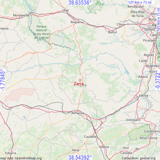
Zarra GPS coordinates[2]
39° 5' 30.3" North, 1° 4' 31.152" West
| Map corner | latitude | longitude |
|---|---|---|
| Upper-left | 39.63536°, | -1.77845° |
| Center: | 39.09175°, | -1.07532° |
| Lower-right: | 38.54392°, | -0.3722° |
| Map W x H: | 121.4×121.4 km | = 75.4×75.4mi |
| max Lat: | 43.74134° ⇑80.3% North |
| Zarra: | 39.09175° |
| min Lat: | ⇓19.7% South 27.64134° |
| min Long | Zarra | max Long |
| -18.00367° | -1.07532° | 4.2899° |
| W 76.5%⇐ | ⇒23.5% E |
Elevation
Elevation of Zarra is 573 m = 1880 ft, and this is 25 m = 82 ft below average elevation for this country.
| Max E: |
1682 m = 5518 ft | 56.5% |
| Avg. | 598 m = 1962 ft | |
| Zarra | 573 m = 1880 ft | |
Min E: |
0 m = 0 ft | 43.5% |
See also: Spain elevation on elevation.city.
Geographical zone
Zarra is located in North temperate zone (between Tropic of Cancer and the Arctic Circle). Distance of this Northern Tropic circle is 1740.7 km =1081.6 mi to South.| Distance of | km | miles | from Zarra |
|---|---|---|---|
| North Pole | 5660.5 | 3517.3 | to North |
| Arctic Circle | 3054.6 | 1898 | to North |
| Tropic Cancer | 1740.7 | 1081.6 | to South |
| Equator | 4346.6 | 2700.9 | to South |


Nearby cities:
15 places around Zarra: (largest is in red/bold)
• Alatoz
24.7 km =15.3 mi,  270°
270°
• Almansa
24.8 km =15.4 mi,  184°
184°
• Alpera
20 km =12.4 mi,  222°
222°
• Ayora
4 km =2.5 mi,  156°
156°
• Balsa de Ves
22.2 km =13.8 mi,  331°
331°
• Bicorp
25.3 km =15.7 mi,  79°
79°
• Carcelén
20.2 km =12.6 mi, 273°
• Casas de Ves
28.4 km =17.6 mi,  308°
308°
• Cofrentes
15.3 km =9.5 mi,  4°
4°
• Cortes de Pallás
21.4 km =13.3 mi,  34°
34°
• Jalance
12.1 km =7.5 mi, 3°
• Jarafuel
5.4 km =3.4 mi, 2°
• Quesa
29.1 km =18.1 mi, 83°
• Teresa de Cofrentes
2.6 km =1.6 mi,  53°
53°
• Villa de Ves
18.2 km =11.3 mi, 311°
Sources, notices
• [Note1] Compared only with cities in Spain existing in our database
• [Src1] Map data: © OpenStreetMap contributors (CC-BY-SA)
• [Src2] Other city data from geonames.org with taken over terms of usage.
• [Src3] Geographical zone / Annual Mean Temperature by Robert A. Rohde @ Wikipedia
