Almansa geodata
Almansa (Castille-La Mancha) is a seat of a third-order administrative division; located in Spain in Europe/Madrid (GMT+2) time zone. With population of 25,727 people, there are 367 cities with bigger population in this country. Compared to other cities in Spain, 82.5% of cities are located further ↑North; 76.3% of cities are located further ←West and 54.2% of cities have lower elevation than Almansa. Note1
Administrative division(s):
- Level 1: Castille-La Mancha
- Level 2: Provincia de Albacete
- Level 3: Almansa


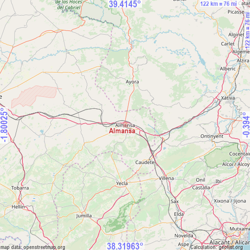
Almansa GPS coordinates[2]
38° 52' 9.012" North, 1° 5' 49.668" West
| Map corner | latitude | longitude |
|---|---|---|
| Upper-left | 39.4145°, | -1.80025° |
| Center: | 38.86917°, | -1.09713° |
| Lower-right: | 38.31963°, | -0.394° |
| Map W x H: | 121.7×121.7 km | = 75.6×75.6mi |
| max Lat: | 43.74134° ⇑82.5% North |
| Almansa: | 38.86917° |
| min Lat: | ⇓17.5% South 27.64134° |
| min Long | Almansa | max Long |
| -18.00367° | -1.09713° | 4.2899° |
| W 76.3%⇐ | ⇒23.7% E |
Elevation
Elevation of Almansa is 702 m = 2303 ft, and this is 104 m = 341 ft above average elevation for this country.
| Max E: |
1682 m = 5518 ft | 45.8% |
| Almansa | 702 m 2303 ft | |
| Avg. | 598 m = 1962 ft | |
Min E: |
0 m = 0 ft | 54.2% |
See also: Spain elevation on elevation.city.
Geographical zone
Almansa is located in North temperate zone (between Tropic of Cancer and the Arctic Circle). Distance of this Northern Tropic circle is 1715.9 km =1066.2 mi to South.| Distance of | km | miles | from Almansa |
|---|---|---|---|
| North Pole | 5685.2 | 3532.6 | to North |
| Arctic Circle | 3079.3 | 1913.4 | to North |
| Tropic Cancer | 1715.9 | 1066.2 | to South |
| Equator | 4321.8 | 2685.4 | to South |


Nearby cities:
15 places around Almansa: (largest is in red/bold)
• Alpera
15.2 km =9.4 mi,  310°
310°
• Ayora
21.3 km =13.2 mi,  9°
9°
• Bonete
21.8 km =13.5 mi,  270°
270°
• Carcelén
31.7 km =19.7 mi,  324°
324°
• Caudete
20.4 km =12.7 mi,  152°
152°
• Corral-Rubio
31.7 km =19.7 mi,  263°
263°
• Fontanars dels Alforins
28.5 km =17.7 mi,  109°
109°
• Higueruela
31.8 km =19.8 mi,  289°
289°
• Jarafuel
30.2 km =18.8 mi,  3°
3°
• La Font de la Figuera
20.1 km =12.5 mi, 112°
• Mogente
29.9 km =18.6 mi,  88°
88°
• Montealegre del Castillo
21.9 km =13.6 mi,  245°
245°
• Teresa de Cofrentes
26.6 km =16.5 mi, 8°
• Yecla
28.5 km =17.7 mi,  183°
183°
• Zarra
24.8 km =15.4 mi, 4°
Sources, notices
• [Note1] Compared only with cities in Spain existing in our database
• [Src1] Map data: © OpenStreetMap contributors (CC-BY-SA)
• [Src2] Other city data from geonames.org with taken over terms of usage.
• [Src3] Geographical zone / Annual Mean Temperature by Robert A. Rohde @ Wikipedia
