Jalance geodata
Jalance (Valencia) is a seat of a third-order administrative division; located in Spain in Europe/Madrid (GMT+2) time zone. With population of 981 people, there are 2977 cities with bigger population in this country. Compared to other cities in Spain, 79.5% of cities are located further ↑North; 76.6% of cities are located further ←West and 68.4% of cities have higher elevation than Jalance. Note1


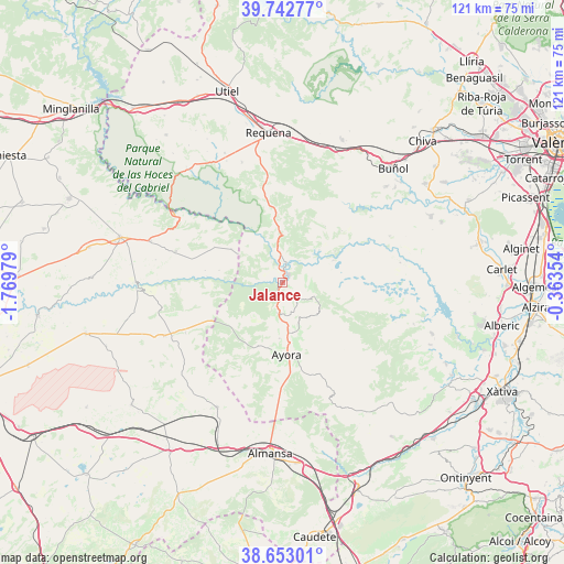
Jalance GPS coordinates[2]
39° 12' 0" North, 1° 4' 0.012" West
| Map corner | latitude | longitude |
|---|---|---|
| Upper-left | 39.74277°, | -1.76979° |
| Center: | 39.2°, | -1.06667° |
| Lower-right: | 38.65301°, | -0.36354° |
| Map W x H: | 121.2×121.2 km | = 75.3×75.3mi |
| max Lat: | 43.74134° ⇑79.5% North |
| Jalance: | 39.2° |
| min Lat: | ⇓20.5% South 27.64134° |
| min Long | Jalance | max Long |
| -18.00367° | -1.06667° | 4.2899° |
| W 76.6%⇐ | ⇒23.4% E |
Elevation
Elevation of Jalance is 409 m = 1342 ft, and this is 189 m = 620 ft below average elevation for this country.
| Max E: |
1682 m = 5518 ft | 68.4% |
| Avg. | 598 m = 1962 ft | |
| Jalance | 409 m = 1342 ft | |
Min E: |
0 m = 0 ft | 31.6% |
See also: Spain elevation on elevation.city.
Geographical zone
Jalance is located in North temperate zone (between Tropic of Cancer and the Arctic Circle). Distance of this Northern Tropic circle is 1752.7 km =1089.1 mi to South.| Distance of | km | miles | from Jalance |
|---|---|---|---|
| North Pole | 5648.4 | 3509.8 | to North |
| Arctic Circle | 3042.5 | 1890.5 | to North |
| Tropic Cancer | 1752.7 | 1089.1 | to South |
| Equator | 4358.6 | 2708.3 | to South |


Nearby cities:
15 places around Jalance: (largest is in red/bold)
• Alatoz
27.9 km =17.3 mi,  245°
245°
• Ayora
15.8 km =9.8 mi,  176°
176°
• Balsa de Ves
13.7 km =8.5 mi,  302°
302°
• Bicorp
25.2 km =15.7 mi,  107°
107°
• Carcelén
23.5 km =14.6 mi,  242°
242°
• Casas de Ves
23.6 km =14.7 mi,  283°
283°
• Cofrentes
3.3 km =2.1 mi,  9°
9°
• Cortes de Pallás
12.8 km =8 mi,  64°
64°
• Dos Aguas
24.8 km =15.4 mi,  68°
68°
• Jarafuel
6.7 km =4.2 mi, 184°
• Millares
26.4 km =16.4 mi,  77°
77°
• Teresa de Cofrentes
10.6 km =6.6 mi,  172°
172°
• Villa de Ves
14.4 km =8.9 mi,  270°
270°
• Villatoya
25 km =15.5 mi,  306°
306°
• Zarra
12.1 km =7.5 mi, 183°
Sources, notices
• [Note1] Compared only with cities in Spain existing in our database
• [Src1] Map data: © OpenStreetMap contributors (CC-BY-SA)
• [Src2] Other city data from geonames.org with taken over terms of usage.
• [Src3] Geographical zone / Annual Mean Temperature by Robert A. Rohde @ Wikipedia
