Ayora geodata
Ayora (Valencia) is a populated place; located in Spain in Europe/Madrid (GMT+2) time zone. With population of 5,508 people, there are 1212 cities with bigger population in this country. Compared to other cities in Spain, 80.5% of cities are located further ↑North; 76.7% of cities are located further ←West and 54.2% of cities have higher elevation than Ayora. Note1
Administrative division(s):
- Level 1: Valencia
- Level 2: Província de València
- Level 3: Teresa de Cofrentes


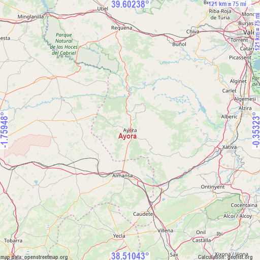
Ayora GPS coordinates[2]
39° 3' 30.672" North, 1° 3' 22.86" West
| Map corner | latitude | longitude |
|---|---|---|
| Upper-left | 39.60238°, | -1.75948° |
| Center: | 39.05852°, | -1.05635° |
| Lower-right: | 38.51043°, | -0.35323° |
| Map W x H: | 121.4×121.4 km | = 75.4×75.4mi |
| max Lat: | 43.74134° ⇑80.5% North |
| Ayora: | 39.05852° |
| min Lat: | ⇓19.5% South 27.64134° |
| min Long | Ayora | max Long |
| -18.00367° | -1.05635° | 4.2899° |
| W 76.7%⇐ | ⇒23.3% E |
Elevation
Elevation of Ayora is 609 m = 1998 ft, and this is 11 m = 36 ft above average elevation for this country.
| Max E: |
1682 m = 5518 ft | 54.2% |
| Ayora | 609 m 1998 ft | |
| Avg. | 598 m = 1962 ft | |
Min E: |
0 m = 0 ft | 45.8% |
See also: Spain elevation on elevation.city.
Geographical zone
Ayora is located in North temperate zone (between Tropic of Cancer and the Arctic Circle). Distance of this Northern Tropic circle is 1737 km =1079.3 mi to South.| Distance of | km | miles | from Ayora |
|---|---|---|---|
| North Pole | 5664.2 | 3519.6 | to North |
| Arctic Circle | 3058.3 | 1900.3 | to North |
| Tropic Cancer | 1737 | 1079.3 | to South |
| Equator | 4342.9 | 2698.6 | to South |


Nearby cities:
15 places around Ayora: (largest is in red/bold)
• Alatoz
26.6 km =16.5 mi,  278°
278°
• Almansa
21.3 km =13.2 mi,  189°
189°
• Alpera
18.7 km =11.6 mi,  233°
233°
• Balsa de Ves
26.2 km =16.3 mi,  331°
331°
• Bicorp
24.6 km =15.3 mi,  70°
70°
• Carcelén
22.3 km =13.9 mi, 282°
• Cofrentes
19 km =11.8 mi,  358°
358°
• Cortes de Pallás
23.8 km =14.8 mi,  26°
26°
• Jalance
15.8 km =9.8 mi, 356°
• Jarafuel
9.2 km =5.7 mi,  350°
350°
• Navarrés
31.6 km =19.6 mi,  81°
81°
• Quesa
28.1 km =17.5 mi, 76°
• Teresa de Cofrentes
5.3 km =3.3 mi,  4°
4°
• Villa de Ves
21.9 km =13.6 mi,  315°
315°
• Zarra
4 km =2.5 mi,  336°
336°
Sources, notices
• [Note1] Compared only with cities in Spain existing in our database
• [Src1] Map data: © OpenStreetMap contributors (CC-BY-SA)
• [Src2] Other city data from geonames.org with taken over terms of usage.
• [Src3] Geographical zone / Annual Mean Temperature by Robert A. Rohde @ Wikipedia
