Aldeaquemada geodata
Aldeaquemada (Andalusia) is a seat of a third-order administrative division; located in Spain in Europe/Madrid (GMT+2) time zone. With population of 529 people, there are 3794 cities with bigger population in this country. Compared to other cities in Spain, 86.1% of cities are located further ↑North; 50.5% of cities are located further →East and 54.1% of cities have lower elevation than Aldeaquemada. Note1


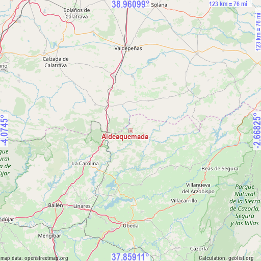
Aldeaquemada GPS coordinates[2]
38° 24' 43.74" North, 3° 22' 16.932" West
| Map corner | latitude | longitude |
|---|---|---|
| Upper-left | 38.96099°, | -4.0745° |
| Center: | 38.41215°, | -3.37137° |
| Lower-right: | 37.85911°, | -2.66825° |
| Map W x H: | 122.5×122.5 km | = 76.1×76.1mi |
| max Lat: | 43.74134° ⇑86.1% North |
| Aldeaquemada: | 38.41215° |
| min Lat: | ⇓13.9% South 27.64134° |
| min Long | Aldeaquemada | max Long |
| -18.00367° | -3.37137° | 4.2899° |
| W 49.5%⇐ | ⇒50.5% E |
Elevation
Elevation of Aldeaquemada is 701 m = 2300 ft, and this is 103 m = 338 ft above average elevation for this country.
| Max E: |
1682 m = 5518 ft | 45.9% |
| Aldeaquemada | 701 m 2300 ft | |
| Avg. | 598 m = 1962 ft | |
Min E: |
0 m = 0 ft | 54.1% |
See also: Spain elevation on elevation.city.
Geographical zone
Aldeaquemada is located in North temperate zone (between Tropic of Cancer and the Arctic Circle). Distance of this Northern Tropic circle is 1665.1 km =1034.6 mi to South.| Distance of | km | miles | from Aldeaquemada |
|---|---|---|---|
| North Pole | 5736 | 3564.2 | to North |
| Arctic Circle | 3130.1 | 1945 | to North |
| Tropic Cancer | 1665.1 | 1034.6 | to South |
| Equator | 4271 | 2653.9 | to South |


Nearby cities:
15 places around Aldeaquemada: (largest is in red/bold)
• Almuradiel
15.7 km =9.8 mi,  315°
315°
• Arquillos
26.1 km =16.2 mi,  190°
190°
• Carboneros
30.4 km =18.9 mi,  228°
228°
• Castellar de Santiago
16.4 km =10.2 mi,  30°
30°
• Castellar de Santisteban
27.3 km =17 mi,  130°
130°
• Chiclana de Segura
30.8 km =19.1 mi,  111°
111°
• La Carolina
26.1 km =16.2 mi, 234°
• Montizón
24.6 km =15.3 mi, 108°
• Navas de San Juan
25.8 km =16 mi,  169°
169°
• Santa Cruz de Mudela
26.9 km =16.7 mi,  342°
342°
• Santa Elena
16.6 km =10.3 mi,  241°
241°
• Santisteban del Puerto
23.2 km =14.4 mi,  141°
141°
• Torrenueva
25.3 km =15.7 mi,  1°
1°
• Vilches
25.8 km =16 mi,  207°
207°
• Viso del Marqués
20.7 km =12.9 mi,  306°
306°
Sources, notices
• [Note1] Compared only with cities in Spain existing in our database
• [Src1] Map data: © OpenStreetMap contributors (CC-BY-SA)
• [Src2] Other city data from geonames.org with taken over terms of usage.
• [Src3] Geographical zone / Annual Mean Temperature by Robert A. Rohde @ Wikipedia
