Carboneros geodata
Carboneros (Andalusia) is a seat of a third-order administrative division; located in Spain in Europe/Madrid (GMT+2) time zone. With population of 704 people, there are 3400 cities with bigger population in this country. Compared to other cities in Spain, 87.1% of cities are located further ↑North; 54.2% of cities are located further →East and 68.7% of cities have higher elevation than Carboneros. Note1


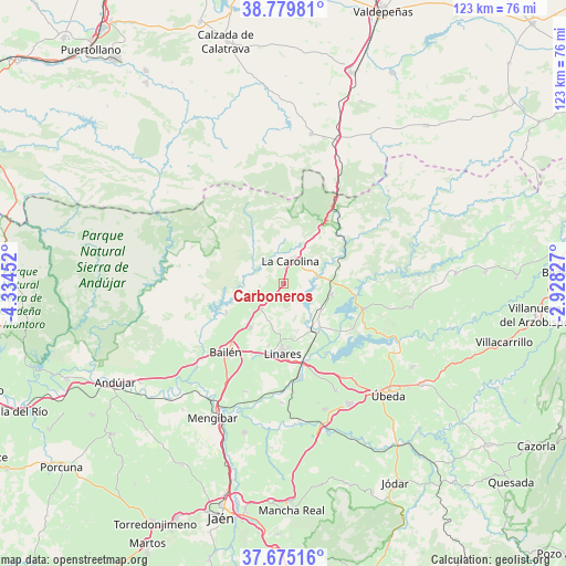
Carboneros GPS coordinates[2]
38° 13' 46.488" North, 3° 37' 53.004" West
| Map corner | latitude | longitude |
|---|---|---|
| Upper-left | 38.77981°, | -4.33452° |
| Center: | 38.22958°, | -3.63139° |
| Lower-right: | 37.67516°, | -2.92827° |
| Map W x H: | 122.8×122.8 km | = 76.3×76.3mi |
| max Lat: | 43.74134° ⇑87.1% North |
| Carboneros: | 38.22958° |
| min Lat: | ⇓12.9% South 27.64134° |
| min Long | Carboneros | max Long |
| -18.00367° | -3.63139° | 4.2899° |
| W 45.8%⇐ | ⇒54.2% E |
Elevation
Elevation of Carboneros is 403 m = 1322 ft, and this is 195 m = 640 ft below average elevation for this country.
| Max E: |
1682 m = 5518 ft | 68.7% |
| Avg. | 598 m = 1962 ft | |
| Carboneros | 403 m = 1322 ft | |
Min E: |
0 m = 0 ft | 31.3% |
See also: Spain elevation on elevation.city.
Geographical zone
Carboneros is located in North temperate zone (between Tropic of Cancer and the Arctic Circle). Distance of this Northern Tropic circle is 1644.8 km =1022 mi to South.| Distance of | km | miles | from Carboneros |
|---|---|---|---|
| North Pole | 5756.3 | 3576.8 | to North |
| Arctic Circle | 3150.4 | 1957.6 | to North |
| Tropic Cancer | 1644.8 | 1022 | to South |
| Equator | 4250.7 | 2641.3 | to South |


Nearby cities:
15 places around Carboneros: (largest is in red/bold)
• Arquillos
18.5 km =11.5 mi,  106°
106°
• Bailén
19.6 km =12.2 mi,  220°
220°
• Baños de la Encina
14 km =8.7 mi,  243°
243°
• Canena
23.9 km =14.9 mi,  147°
147°
• Guarromán
7.1 km =4.4 mi, 223°
• Ibros
25.8 km =16 mi, 154°
• Jabalquinto
24.8 km =15.4 mi,  199°
199°
• La Carolina
5.3 km =3.3 mi,  15°
15°
• Linares
14.9 km =9.3 mi,  181°
181°
• Lupión
26.9 km =16.7 mi,  164°
164°
• Navas de San Juan
28 km =17.4 mi,  100°
100°
• Rus
25.1 km =15.6 mi,  143°
143°
• Santa Elena
14.8 km =9.2 mi,  32°
32°
• Torreblascopedro
25.8 km =16 mi, 181°
• Vilches
10.9 km =6.8 mi, 103°
Sources, notices
• [Note1] Compared only with cities in Spain existing in our database
• [Src1] Map data: © OpenStreetMap contributors (CC-BY-SA)
• [Src2] Other city data from geonames.org with taken over terms of usage.
• [Src3] Geographical zone / Annual Mean Temperature by Robert A. Rohde @ Wikipedia
