Santa Elena geodata
Santa Elena (Andalusia) is a seat of a third-order administrative division; located in Spain in Europe/Madrid (GMT+2) time zone. With population of 996 people, there are 2954 cities with bigger population in this country. Compared to other cities in Spain, 86.5% of cities are located further ↑North; 52.8% of cities are located further →East and 62.3% of cities have lower elevation than Santa Elena. Note1


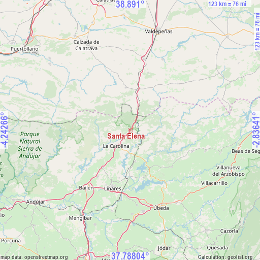
Santa Elena GPS coordinates[2]
38° 20' 29.832" North, 3° 32' 22.308" West
| Map corner | latitude | longitude |
|---|---|---|
| Upper-left | 38.891°, | -4.24266° |
| Center: | 38.34162°, | -3.53953° |
| Lower-right: | 37.78804°, | -2.83641° |
| Map W x H: | 122.6×122.6 km | = 76.2×76.2mi |
| max Lat: | 43.74134° ⇑86.5% North |
| Santa Elena: | 38.34162° |
| min Lat: | ⇓13.5% South 27.64134° |
| min Long | Santa Elena | max Long |
| -18.00367° | -3.53953° | 4.2899° |
| W 47.2%⇐ | ⇒52.8% E |
Elevation
Elevation of Santa Elena is 759 m = 2490 ft, and this is 161 m = 528 ft above average elevation for this country.
| Max E: |
1682 m = 5518 ft | 37.7% |
| Santa Elena | 759 m 2490 ft | |
| Avg. | 598 m = 1962 ft | |
Min E: |
0 m = 0 ft | 62.3% |
See also: Spain elevation on elevation.city.
Geographical zone
Santa Elena is located in North temperate zone (between Tropic of Cancer and the Arctic Circle). Distance of this Northern Tropic circle is 1657.3 km =1029.8 mi to South.| Distance of | km | miles | from Santa Elena |
|---|---|---|---|
| North Pole | 5743.9 | 3569.1 | to North |
| Arctic Circle | 3138 | 1949.9 | to North |
| Tropic Cancer | 1657.3 | 1029.8 | to South |
| Equator | 4263.2 | 2649 | to South |


Nearby cities:
15 places around Santa Elena: (largest is in red/bold)
• Aldeaquemada
16.6 km =10.3 mi,  61°
61°
• Almuradiel
19.4 km =12.1 mi,  10°
10°
• Arquillos
20.3 km =12.6 mi,  151°
151°
• Baños de la Encina
27.8 km =17.3 mi,  227°
227°
• Canena
32.9 km =20.4 mi,  171°
171°
• Carboneros
14.8 km =9.2 mi,  212°
212°
• Castellar de Santiago
31.8 km =19.8 mi,  46°
46°
• Guarromán
21.9 km =13.6 mi,  216°
216°
• La Carolina
9.9 km =6.2 mi, 222°
• Linares
28.7 km =17.8 mi,  197°
197°
• Navas de San Juan
26.2 km =16.3 mi,  131°
131°
• San Lorenzo de Calatrava
29.1 km =18.1 mi,  301°
301°
• Santisteban del Puerto
30.8 km =19.1 mi,  109°
109°
• Vilches
15.2 km =9.4 mi, 170°
• Viso del Marqués
20.2 km =12.6 mi,  354°
354°
Sources, notices
• [Note1] Compared only with cities in Spain existing in our database
• [Src1] Map data: © OpenStreetMap contributors (CC-BY-SA)
• [Src2] Other city data from geonames.org with taken over terms of usage.
• [Src3] Geographical zone / Annual Mean Temperature by Robert A. Rohde @ Wikipedia
