Villarrubia geodata
Villarrubia (Andalusia) is a populated place; located in Spain in Europe/Madrid (GMT+2) time zone. With population of 2,893 people, there are 1760 cities with bigger population in this country. Compared to other cities in Spain, 89.3% of cities are located further ↑North; 71.1% of cities are located further →East and 88.1% of cities have higher elevation than Villarrubia. Note1


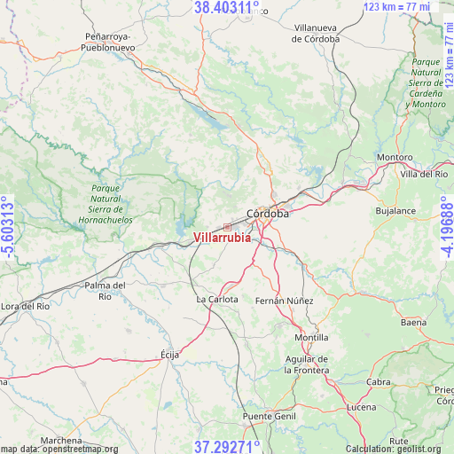
Villarrubia GPS coordinates[2]
37° 51' 0" North, 4° 54' 0" West
| Map corner | latitude | longitude |
|---|---|---|
| Upper-left | 38.40311°, | -5.60313° |
| Center: | 37.85°, | -4.9° |
| Lower-right: | 37.29271°, | -4.19688° |
| Map W x H: | 123.5×123.5 km | = 76.7×76.7mi |
| max Lat: | 43.74134° ⇑89.3% North |
| Villarrubia: | 37.85° |
| min Lat: | ⇓10.7% South 27.64134° |
| min Long | Villarrubia | max Long |
| -18.00367° | -4.9° | 4.2899° |
| W 28.9%⇐ | ⇒71.1% E |
Elevation
Elevation of Villarrubia is 93 m = 305 ft, and this is 505 m = 1657 ft below average elevation for this country.
| Max E: |
1682 m = 5518 ft | 88.1% |
| Avg. | 598 m = 1962 ft | |
| Villarrubia | 93 m = 305 ft | |
Min E: |
0 m = 0 ft | 11.9% |
See also: Spain elevation on elevation.city.
Geographical zone
Villarrubia is located in North temperate zone (between Tropic of Cancer and the Arctic Circle). Distance of this Northern Tropic circle is 1602.6 km =995.8 mi to South.| Distance of | km | miles | from Villarrubia |
|---|---|---|---|
| North Pole | 5798.5 | 3603 | to North |
| Arctic Circle | 3192.6 | 1983.8 | to North |
| Tropic Cancer | 1602.6 | 995.8 | to South |
| Equator | 4208.5 | 2615 | to South |


Nearby cities:
15 places around Villarrubia: (largest is in red/bold)
• Almodóvar del Río
11.4 km =7.1 mi,  247°
247°
• Córdoba
12.1 km =7.5 mi,  67°
67°
• Fernán-Núñez
25.1 km =15.6 mi,  142°
142°
• Fuente Palmera
23.8 km =14.8 mi,  227°
227°
• Guadalcázar
11 km =6.8 mi,  200°
200°
• Hornachuelos
29.3 km =18.2 mi,  266°
266°
• La Carlota
19.8 km =12.3 mi,  187°
187°
• La Rambla
30.4 km =18.9 mi,  152°
152°
• La Victoria
19.2 km =11.9 mi,  167°
167°
• Montemayor
28.7 km =17.8 mi, 141°
• Posadas
19 km =11.8 mi, 253°
• San Sebastián de los Ballesteros
22.8 km =14.2 mi,  162°
162°
• Santaella
32.3 km =20.1 mi, 171°
• Villaharta
31.5 km =19.6 mi,  0°
0°
• Villaviciosa de Córdoba
27.9 km =17.3 mi,  338°
338°
Sources, notices
• [Note1] Compared only with cities in Spain existing in our database
• [Src1] Map data: © OpenStreetMap contributors (CC-BY-SA)
• [Src2] Other city data from geonames.org with taken over terms of usage.
• [Src3] Geographical zone / Annual Mean Temperature by Robert A. Rohde @ Wikipedia
