Torreperogil geodata
Torreperogil (Andalusia) is a seat of a third-order administrative division; located in Spain in Europe/Madrid (GMT+2) time zone. With population of 6,786 people, there are 1058 cities with bigger population in this country. Compared to other cities in Spain, 88.3% of cities are located further ↑North; 50.6% of cities are located further ←West and 61.9% of cities have lower elevation than Torreperogil. Note1


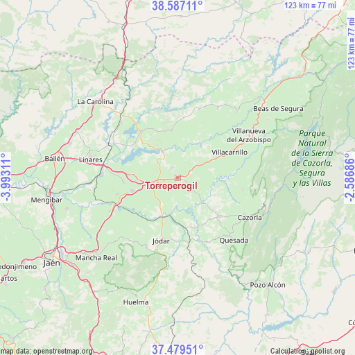
Torreperogil GPS coordinates[2]
38° 2' 7.44" North, 3° 17' 23.928" West
| Map corner | latitude | longitude |
|---|---|---|
| Upper-left | 38.58711°, | -3.99311° |
| Center: | 38.0354°, | -3.28998° |
| Lower-right: | 37.47951°, | -2.58686° |
| Map W x H: | 123.2×123.2 km | = 76.6×76.6mi |
| max Lat: | 43.74134° ⇑88.3% North |
| Torreperogil: | 38.0354° |
| min Lat: | ⇓11.7% South 27.64134° |
| min Long | Torreperogil | max Long |
| -18.00367° | -3.28998° | 4.2899° |
| W 50.6%⇐ | ⇒49.4% E |
Elevation
Elevation of Torreperogil is 756 m = 2480 ft, and this is 158 m = 518 ft above average elevation for this country.
| Max E: |
1682 m = 5518 ft | 38.1% |
| Torreperogil | 756 m 2480 ft | |
| Avg. | 598 m = 1962 ft | |
Min E: |
0 m = 0 ft | 61.9% |
See also: Spain elevation on elevation.city.
Geographical zone
Torreperogil is located in North temperate zone (between Tropic of Cancer and the Arctic Circle). Distance of this Northern Tropic circle is 1623.2 km =1008.6 mi to South.| Distance of | km | miles | from Torreperogil |
|---|---|---|---|
| North Pole | 5777.9 | 3590.2 | to North |
| Arctic Circle | 3172 | 1971 | to North |
| Tropic Cancer | 1623.2 | 1008.6 | to South |
| Equator | 4229.1 | 2627.8 | to South |


Nearby cities:
15 places around Torreperogil: (largest is in red/bold)
• Arquillos
20.3 km =12.6 mi,  323°
323°
• Baeza
16.5 km =10.3 mi,  253°
253°
• Begíjar
21.8 km =13.5 mi,  255°
255°
• Benatae
21.8 km =13.5 mi,  38°
38°
• Canena
17 km =10.6 mi,  275°
275°
• Hornos
18.8 km =11.7 mi,  151°
151°
• Ibros
18.7 km =11.6 mi,  265°
265°
• Navas de San Juan
16.7 km =10.4 mi,  352°
352°
• Peal de Becerro
20.1 km =12.5 mi,  132°
132°
• Rus
15.2 km =9.4 mi, 275°
• Sabiote
4.3 km =2.7 mi,  330°
330°
• Santo Tomé
16.6 km =10.3 mi,  92°
92°
• Solana de Torralba
11.6 km =7.2 mi,  116°
116°
• Villacarrillo
20.1 km =12.5 mi,  63°
63°
• Úbeda
7.5 km =4.7 mi, 250°
Sources, notices
• [Note1] Compared only with cities in Spain existing in our database
• [Src1] Map data: © OpenStreetMap contributors (CC-BY-SA)
• [Src2] Other city data from geonames.org with taken over terms of usage.
• [Src3] Geographical zone / Annual Mean Temperature by Robert A. Rohde @ Wikipedia
